Laser Altimetry Data for SMB Reconstruction Evaluation
Project Summary
The surface mass balance (SMB) of the Greenland Ice Sheet critically
depend on the intensity of ice/snow melt in its ablation zone, but
in-situ data have been too limited to quantify the error of regional
climate models. Here, we use 23 years of NASA satellite and airborne
laser altimetry from the Airborne Topographic Mapper (ATM), Land,
Vegetation and Ice Sensor (LVIS) and Ice, Cloud and land Elevation
Satellite (ICESat) to generate time series of elevation change to
compare with SMB products from the Regional Atmospheric Climate Model
(RACMO2.3p2) and from the Modèle Atmosphérique Régional
(MARv3.5.2). For 1994–2016, the results agree at the
15–26% level, with the largest discrepancy in north Greenland.
During the cold summer 2015, the RMS discrepancy is 40% in the
north, 30% in the southwest, and 18–25% at low elevation.
The difference drops to 23% in the southwest and 14% at low
elevation during the 2016 warm summer.
Funding
This work was performed at UC Irvine and JPL-Caltech funded by grants
from the NASA's Cryosphere, Terrestrial Hydrology, Interdisciplinary
Science, and MEASURES-2 Programs.
Highlight
Assess the accuracy of reconstructed runoff from Regional
Climate Models, a dominant control on the Greenland Ice Sheet mass balance.
Time series of mass changes from 23 years of altimetry and
seasonal data indicate that the error in runoff is at the 20% level.
Airborne laser altimetry provides orders of magnitude more
data for regional climate model assessment than available in situ.
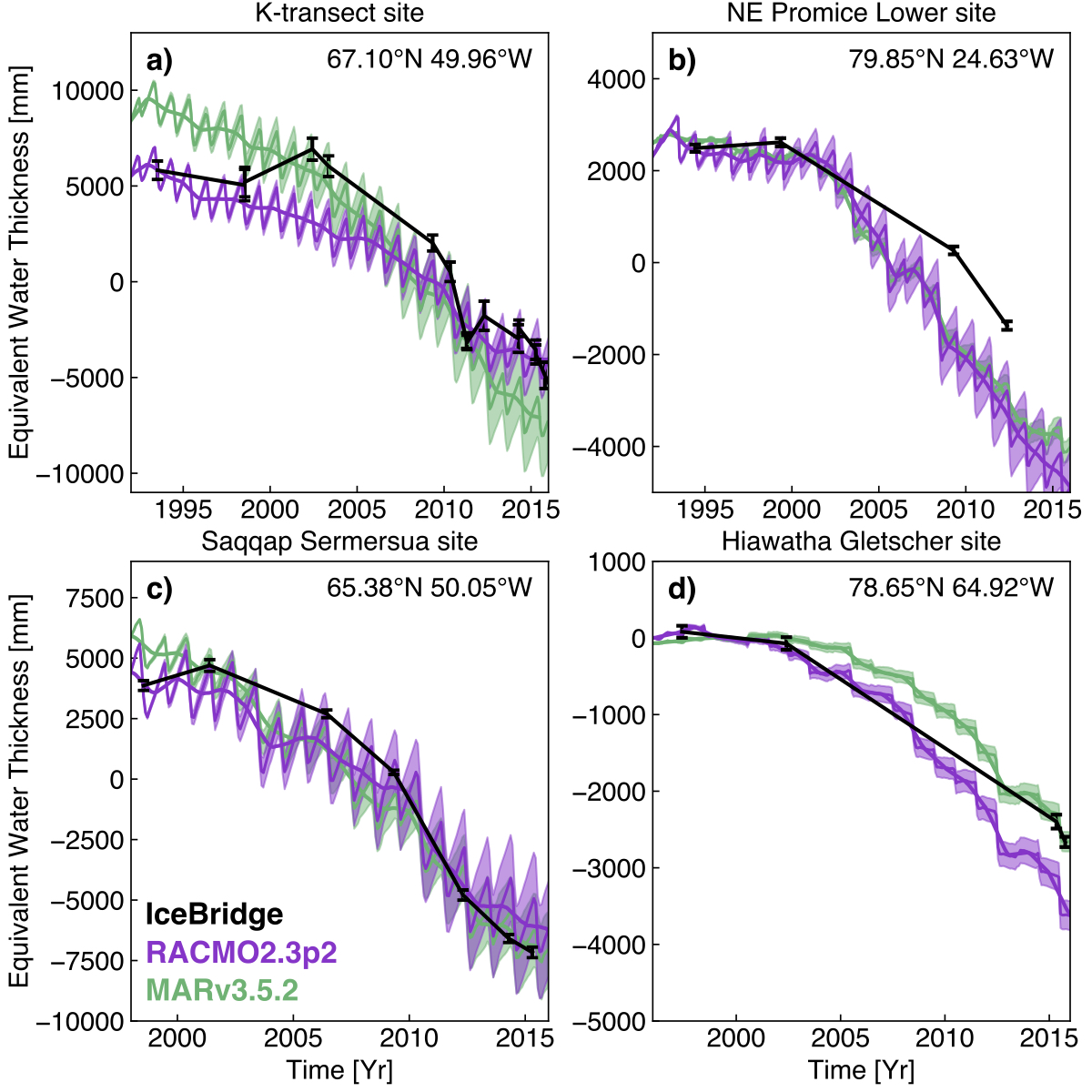
Comparisons of Operation IceBridge (OIB) laser altimetry (black),
RACMO2.3p2 surface mass balance (SMB) (purple) and MARv3.5.2 SMB
(green) at a) Site 5 of the K-transect in West Greenland, b) NE
Promice Lower in Northeast Greenland, c) Saqqap Sermersua in
Southwest Greenland, and d) Hiawatha Gletscher in North Greenland.
Thick purple and green lines are the 13-month smoothed SMB time
series (Velicogna, 2009).
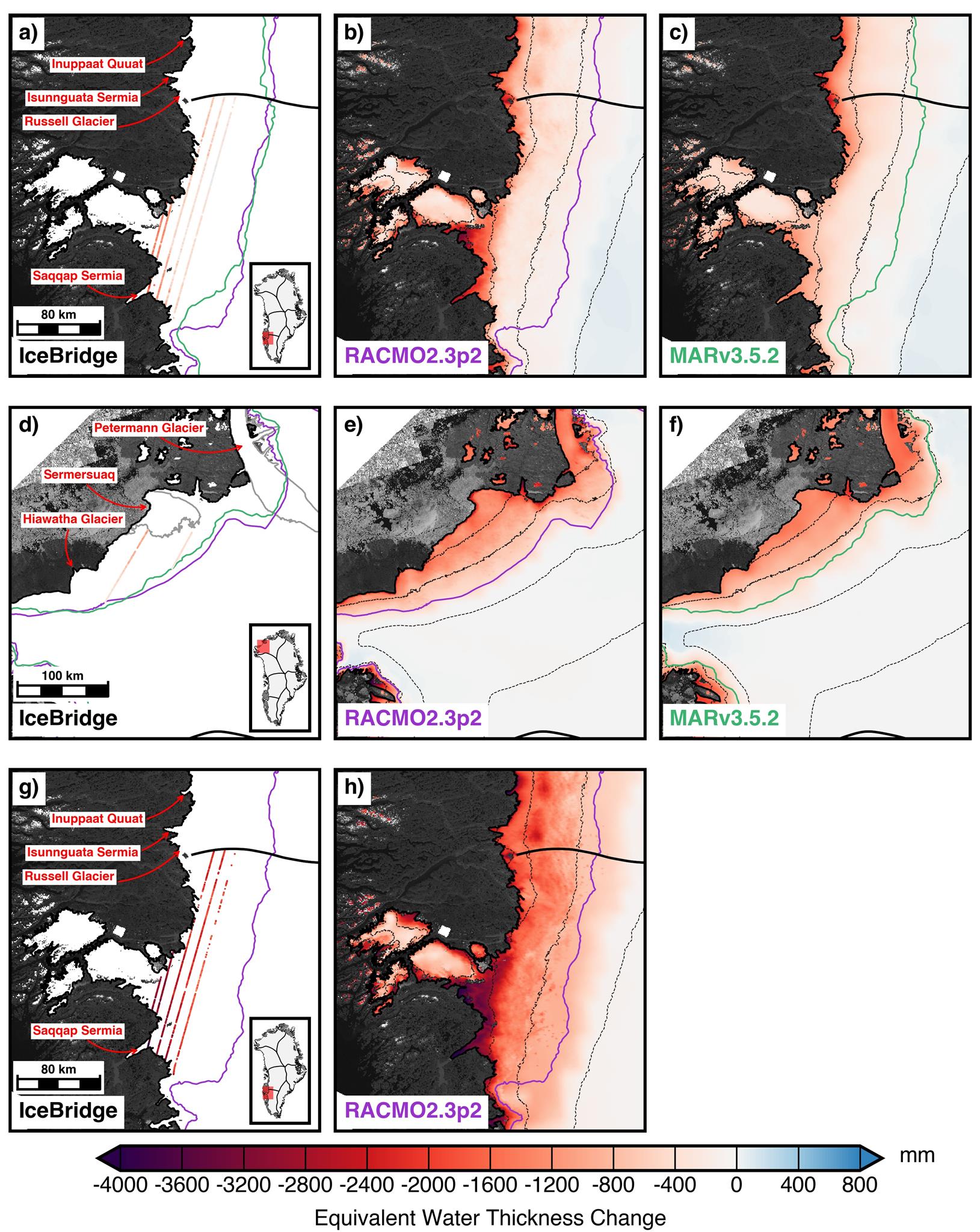
Comparisons of mass change from a,d,g) Operation IceBridge (OIB) laser
altimetry, b,e,h) RACMO2.3p2 surface mass balance (SMB) and c,f)
MARv3.5.2 SMB over the 2015 summer season for (a-c) Southwest
Greenland and (d-f) North Greenland and over the 2016 summer
season for (g-h) Southwest Greenland. OIB combines data from
April 18, 2015 with data collected during 7 days in October 2015
for (a-c), data from May 5, 2015 and 2 days in October 2015
for (d-f) and data from May 14, 2016 with data collected during
6 days in August and September 2016 for (g-h). SMB outputs from
MARv3.5.2 are not available for 2016. Purple and green lines are
the ELA positions from RACMO2 and MAR, respectively, for the
period 1993–2015. Gray lines in d) denote the 100 m/yr ice
speed contour from Rignot et al. (2012). Thick black lines denote
ice divides from Rignot et al. (2012). Dashed lines denote 500 m
elevation contours from the Greenland Ice Mapping Project (GIMP)
(Howat et al., 2014). Inset map denotes the location of the maps.
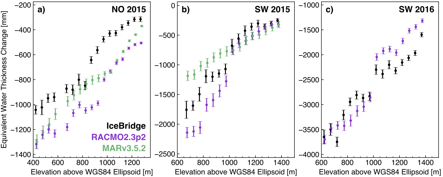
Mass change over elevation bands from Operation IceBridge laser
altimetry (black), RACMO2.3p2 SMB (purple) and MARv3.5.2 SMB (green)
over the summer seasons from a) 2015 in NO Greenland, b) 2015 in SW
Greenland and c) 2016 in SW Greenland.
Please cite the paper below when using the provided dataset
Sutterley, T. C., I. Velicogna, X. Fettweis, E. Rignot, B. Noël,
and M. van den Broeke, 2018: Evaluation of reconstructions of snow/ice
melt in Greenland by regional atmospheric climate models using laser
altimetry data, Geophysical Research Letters, 45, 8324–8333, (2018).
doi: 10.1029/2018GL078645
Link to Data and Documentation:
* required field.
(Download link will be provided after entering your name and email so we can send out email notification to you if any data is updated.
For questions please contact tyler.c.sutterley@nasa.gov or isabella@uci.edu.