The U.S. National Aeronautics and Space Administration (NASA) operates several ER-2s as high-altitude, atmospheric-sensing platforms. They collect in-situ and remotely-sensed data on atmospheric chemistry, radiation, and dynamics as well as surface and oceanic information. As a result, these aircraft are frequently used for calibration and validation of satellite data. The ER-2 has also been used for natural disaster assessments and aerial photography.
The NASA High Altitude Aircraft Program was started in 1971 using two Lockheed U-2C aircraft, then designated as the ER-2. They were used by NASA throughout the 70's and into the 80's primarily for multispectral photography. In 1981, NASA acquired the U2-R (or TR-1) which was both longer and possessed a wider wingspan than the U2-C although the designation remained ER-2. The ER-2 specifications are given in Table 3.1. The first campaign flown by the ER-2 in more or less its current configuration was in support of the Airborne Antarctic Ozone Expedition (AAOE) in 1987 to probe the newly-discovered Antarctic ozone hole. It carried a wide variety of scientific instrumentation which sampled temperature, pressure, winds, aerosols, and wide variety of trace gases. The ER-2 was later employed for the Airborne Arctic Stratospheric Expedition (AASE) I during in 1989 and AASE II in 1991 to study the Arctic stratosphere.
|
In 1992, the Composition and Photodissociative Flux Measurement (CPFM) was added as part of the ER-2 instrumentation for the Stratospheric Photochemistry, Aerosols and Dynamics Expedition (SPADE) campaign. The CPFM is a small spectroradiometer installed on the right wing of the ER-2 and is described in Section 3.2. Later campaigns which included the CPFM were the Antarctic Southern Hemisphere Ozone Experiment/Measurements for Assessing the Effects of Stratospheric Aircraft (ASHOE/MAESA), the Stratospheric Tracers of Atmospheric Transport (STRAT) and the latest, Photochemistry of Ozone Loss in the Arctic Region In Summer (POLARIS). It will be the analysis of CPFM measurements made during these recent campaigns that will be the focus of this study. A summary of these is provided in Table 3.2.
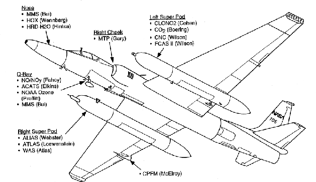
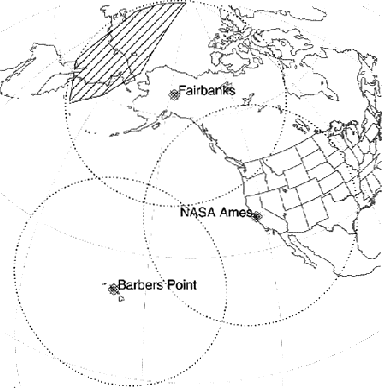
While the primary objectives of each of these four campaigns were different, all share a common goal: to improve our understanding of chemistry, dynamics, and radiation in the upper troposphere and lower stratosphere. The primary goals of the individual campaigns are summarized below. SPADE was to assess the key chemical processes that could potentially affect ozone levels in the part of the stratosphere that would be strongly influenced by future stratospheric aviation (SPADE manual). The primary goal of ASHOE was to examine the causes of ozone loss in the Southern Hemisphere lower stratosphere and how this loss is related to polar, mid-latitude, and tropical processes. In concert with ASHOE, MAESA continued to assess the environmental effects of stratospheric aviation (ASHOE/MAESA manual). The STRAT campaign measured long-lived tracers and dynamical quantities in an effort to help determine rates for global-scale transport from stratospheric aviation (STRAT manual). Finally, the primary objective of POLARIS was to investigate and obtain a better understanding of the variation in polar ozone from high springtime levels to much lower levels in autumn. The ER-2 as configured for POLARIS is shown in Figure 3.1 and the POLARIS deployments locations and areas of operation are shown in Figure 3.2.
Each of these campaigns shared an impressive compliment of remote and in-situ instrumentation, often two-dozen or more. A summary of the these, along with their principle investigators, is given in Table 3.3. The installation of these instruments on the ER-2 is shown in Figure 3.1. In support of the ER-2 campaigns, there has been collaborations involving balloon flights, ozone and radiosondes, satellite passes, and extensive modeling.
|