|
1
|
|
|
2
|
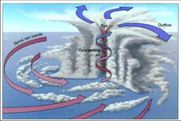
|
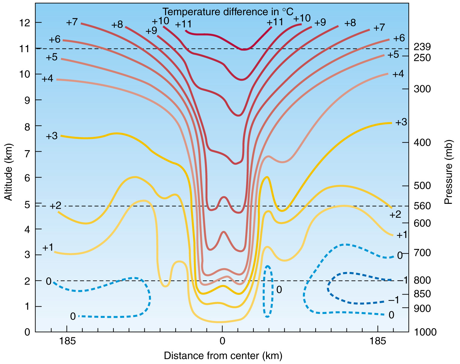
|
3
|
|
|
4
|
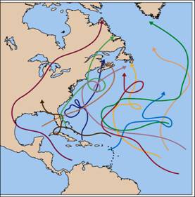
|
|
5
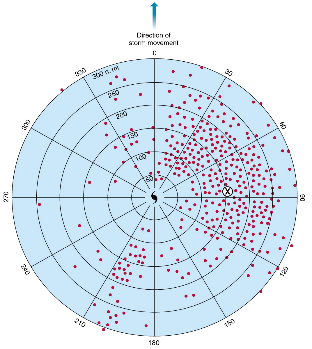
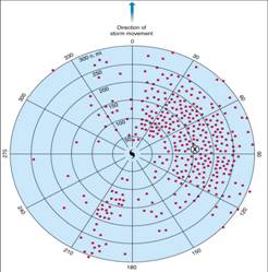
|
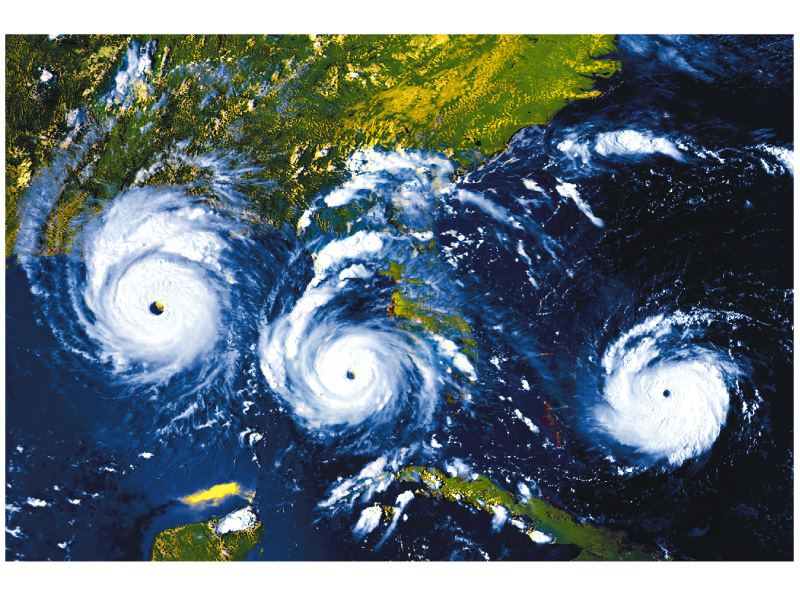
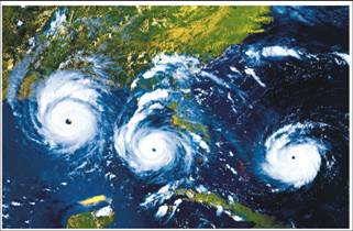
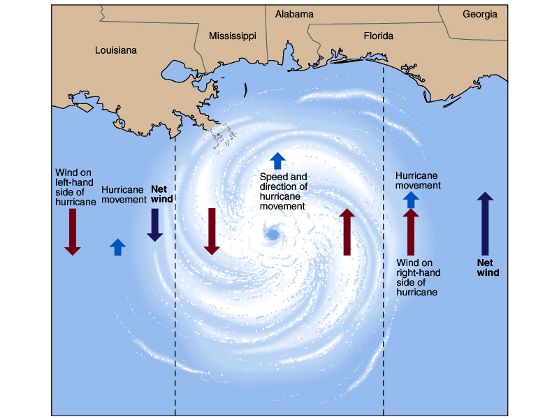
- Definition: Hurricanes have
sustained winds of 120 km/hr (74 mph) or greater.
- Size: Average diameters are
approximately 600 km (350 mi). (one third the size of mid-latitude
cyclone)
- Duration: days to a week or
more.
- Strength: Central pressure
averages about 950 mb but may be as low as 870 mb.
- Power: The energy released by a
single hurricane can exceed the annual electricity consumption of the
US and Canada.
|
|
6
|
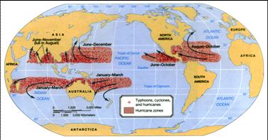
- Hurricanes obtain their energy
from latent heat release in the cloud formation process.
- Hurricanes occur where a deep
layer of warm waters exists and during the times of highest SSTs.
- For the N.H., August and September are the most active months.
- For the S.H., the hurricane season is January-March.
|
|
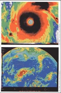
7
|
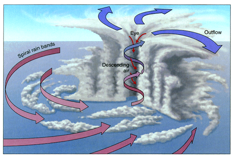
- A central eye surrounded by large cumulonimbus thunderstorms occupying
the adjacent eye wall.
- Weak uplift and low precipitation regions separate individual cloud
bands.
|
|
8
|
- Hurricane is characterized by a strong thermally direct circulation with
the rising of warm air near the center of the storm and the sinking of
cooler air outside.
- The warm core of the hurricane serves as a reservoir of potential
energy, which is continuously being converted into kinetic energy by the
thermally direct circulation.
|
|
9
|
- The horizontal pressure gradient with altitude decreases slowly.
- At about 400 mb, pressures within the storm are approximate to that
outside.
- Surface-400mb: Cyclonic circulation.
- 400mb-tropopause: anticyclonic circulation.
|
|
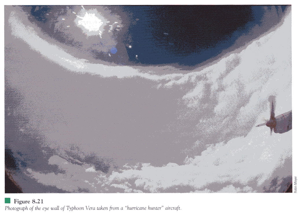
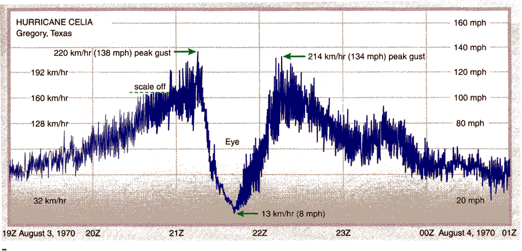
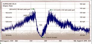
10
|
- The eye is an area of descending air, relatively clear sky, and light
winds which is about 25 km (15 mi) in diameter on average.
- A shrinking eye indicates storm intensification.
- The eye wall is comprised of the strongest winds, the largest clouds,
and the heaviest precipitation with rainfall rates as high as 2500
mm/day (100 in.).
|
|
11
|
|
|
12
|
- Tropical Disturbance: Clusters of small thunderstorms.
- Tropical Depression: When at least one closed isobar is present, the
disturbance is classified as a tropical depression.
- Tropical Storm: Further intensification, to wind speeds of 60 km/hr (37
mph), place the storm in the category of tropical storm.
- Hurricane: Hurricane status is gained when winds reach or exceed 120
km/hr (74 mph).
|
|
13
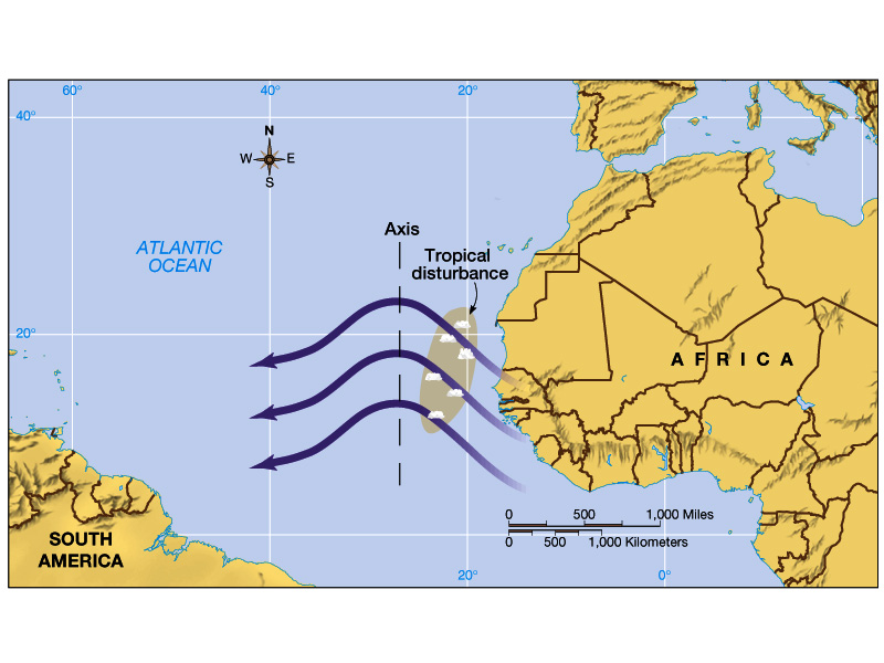
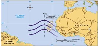
|
- Some tropical disturbances form in association with mid-latitude troughs
migrating toward lower latitudes, some form from ITCZ-related
convection, but most develop from easterly waves.
- Easterly waves, or undulations in the trade wind pattern, spawn
hurricanes in the Atlantic (typically 2–3000 km).
- Only about 10% tropical disturbances intensify into more organized,
rotating storms.
|
|
14
|
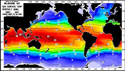
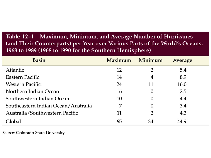
- Hurricanes form only over deep
(several tens of meters) water layers with surface temperatures in
excess of 27 oC.
- Poleward of about 20o,
water temperatures are usually below this threshold
- Hurricanes are most frequent
in late summer and early autumn during high SST times
- Coriolis force is an important
contributor, and as such, hurricanes do not form equatorward of 5o.
- Need an unstable atmosphere:
available in the western tropical ocean bur not in the eastern parts
of the ocean.
- Strong vertical shear must be absent for hurricane formation.
|
|
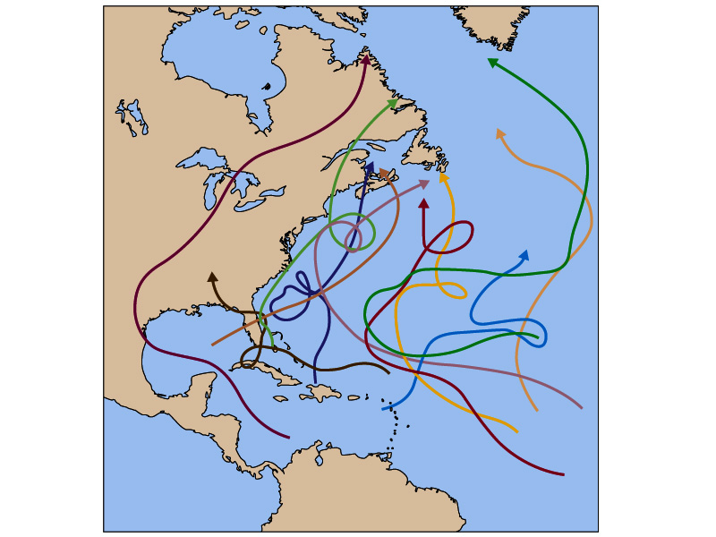
15
|
- Tropical disturbances and
depressions are largely regulated by trade wind flow and simply move
westward.
- For tropical storms and hurricanes, upper-level winds and ocean
temperatures gain importance .
- Fully developed hurricanes move poleward.
|
|
16
|
- After making landfall, a tropical
storm may die out completely within a few days.
- Even as the storm weakens, it can
still bring in huge amount of water vapor and rainfall hundreds of
kilometers inland.
|
|
17
|
- Heavy rainfalls
- Strong winds
- Tornadoes
- Storm Surges: A rise in water
level induced by the hurricane.
|
|
18
|
- Most hurricanes also contain clusters of tornadoes.
- Most pf these tornadoes occur in the right front quarter of the
hurricane movement.
- It appears the slowing of the wind by friction at landfall contribute to
the formation of tornadoes.
|
|
19
|
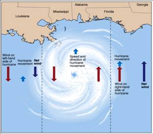
- Winds and surge are typically most intense in the right front quadrant
of the storm where wind speeds combine with the speed of the storm’s
movement to create the area of highest potential impact.
|
|
20
|
- Process 1: Hurricane winds drag
surface waters forward and pileup the waters near coasts.
- Process 2: Lower atmospheric
pressure raises sea level (for every 1 mb pressure decrease, sea level
raises 1 cm).
- Storm surges raise costal sea
level by a meter or two for most hurricanes, but can be as much as 7
meters.
|
|
21
|
- Middle 1990s-Now: A significant
increase in the numbers of hurricanes and intense hurricanes making
landfall in the United States.
- 1970s-middle 1990s: lower than
normal incidence of Atlantic hurricanes.
- It is still in debate where the
recent increase of hurricane and its intensity is a sign of global
warming or a part of natural multi-decadal cycle.
|
|
22
|
- The National Hurricane Center is responsible for predicting and tracking
Atlantic and east Pacific hurricanes.
- Data are gathered through satellite observations, surface observations,
and aircraft using dropsondes.
- Statistical, dynamic, and hybrid computer models running on
supercomputers assist in future track position and storm intensity
predictions.
- Future positions are given along six-hour trajectories with accuracy
decreasing as lead time increases.
|
|
23
|
- Hurricane watch: if an
approaching hurricane is predicted to reach land in more than 24 hours.
- Hurricane Warning: if the time
frame is less, a warning is given.
|
|
24
|
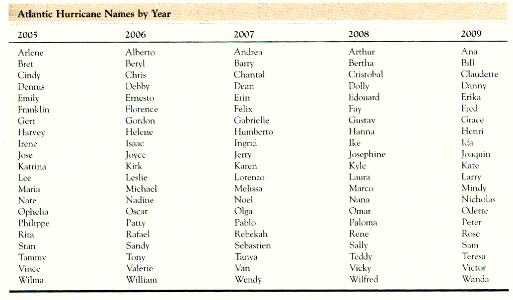
- When a tropical disturbance
reaches the stage of tropical storm, it will be given a name.
- The name come from a A-W list created by World Meteorological
Organization (WMO).
- Six lists are created for the Atlantic Ocean, each list is used for one
hurricane season.
- The names of the hurricanes that cause devastating damages are removed
from the list forever.
|
|
25
|
|
|
26
|
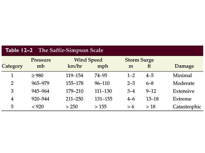
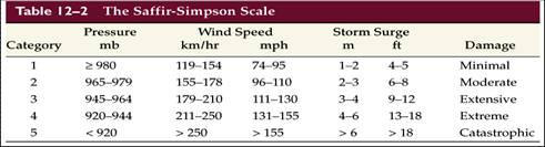
- The Saffir-Simpson scale.
- Five categories: larger numbers
indicate lower central pressure, greater winds, and stronger storm
surges.
|

 Notes
Notes