|
1
|
|
|
2
|
- Air masses
- Contain uniform temperature
and
- humidity characteristics.
- Fronts
- Boundaries between unlike air
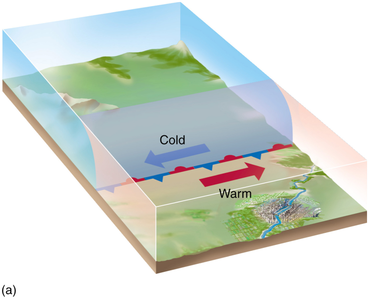
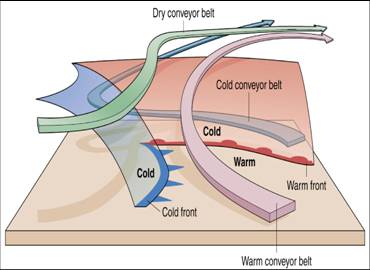
- masses.
|
|
3
|
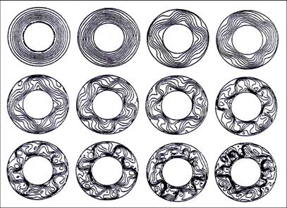
- Air masses have fairly uniform
temperature and moisture content in horizontal direction (but not
uniform in vertical).
- Air masses are characterized by
their temperature and humidity properties.
- The properties of air masses are
determined by the underlying surface properties where they originate.
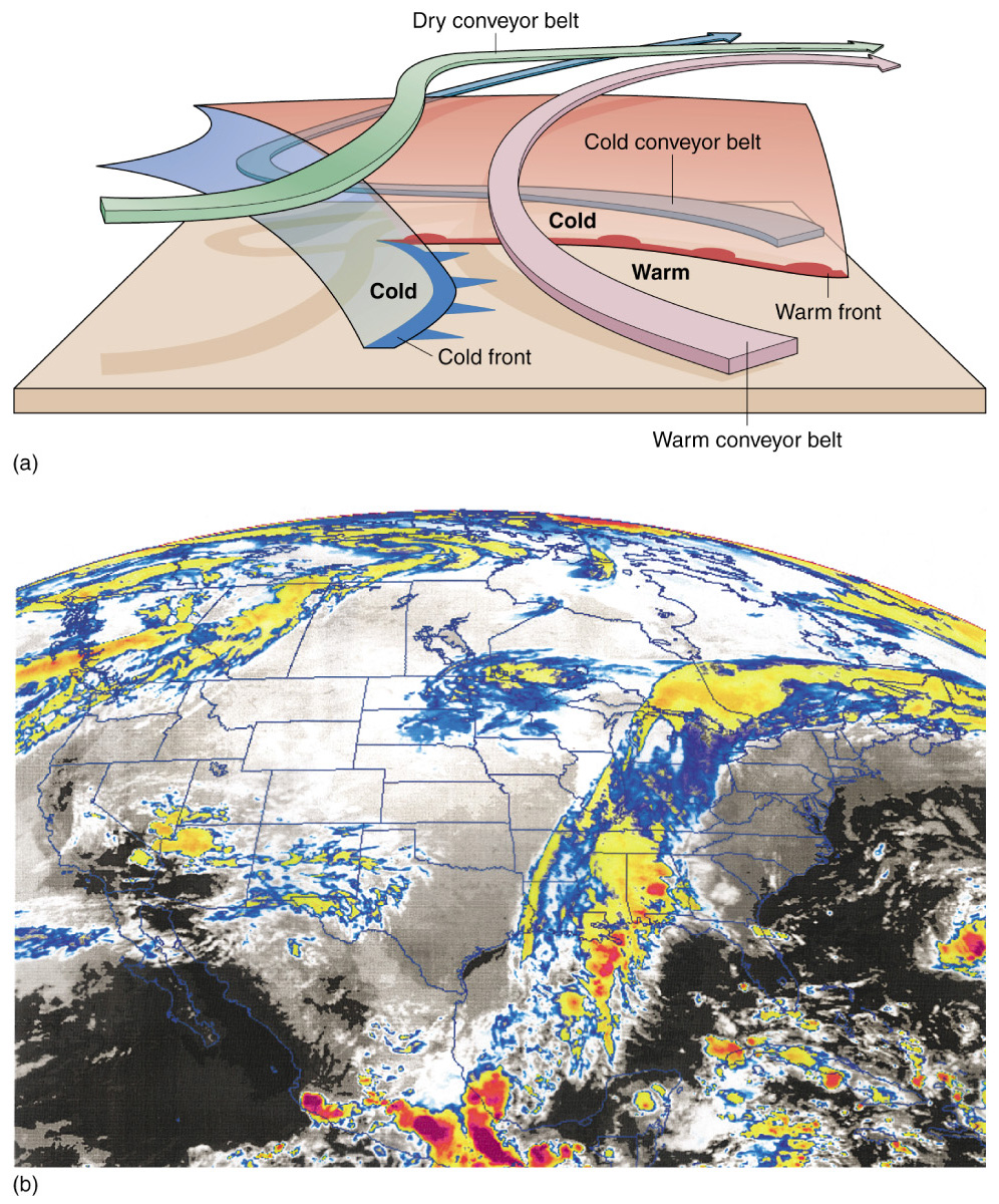
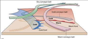
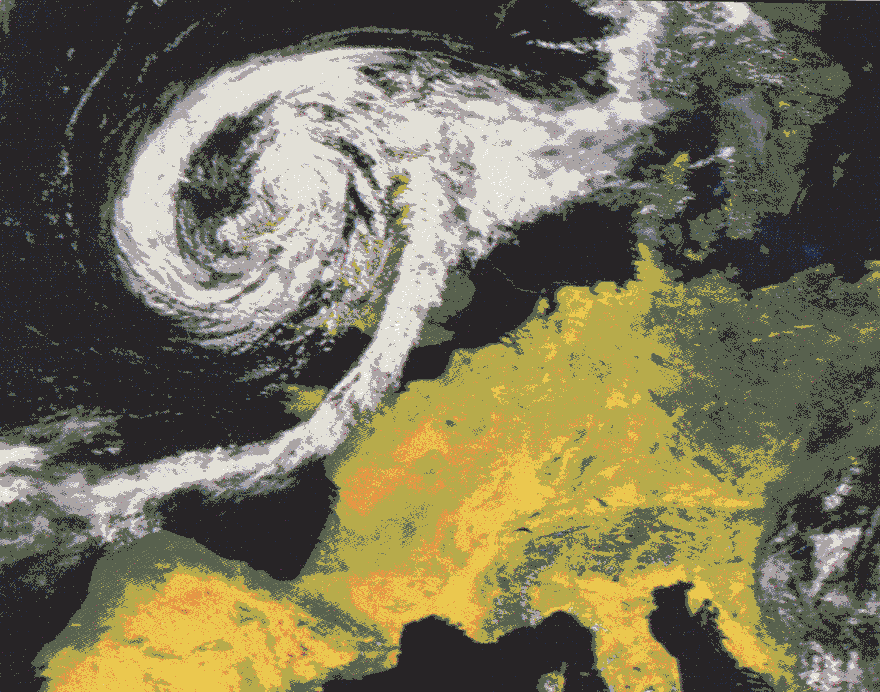
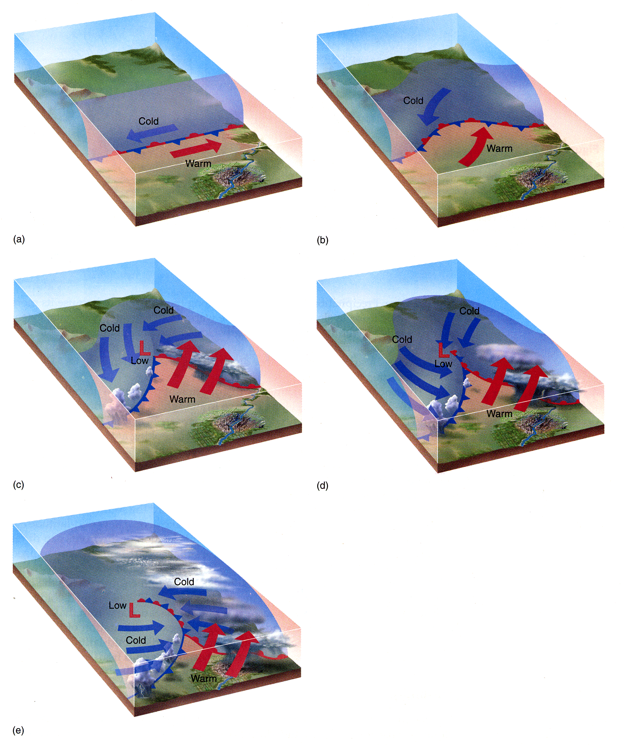
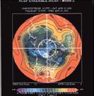
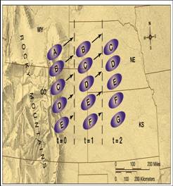
- Once formed, air masses migrate within the general circulation.
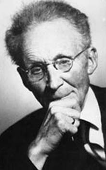
- Upon movement, air masses displace residual air over locations thus
changing temperature and humidity characteristics.
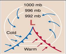
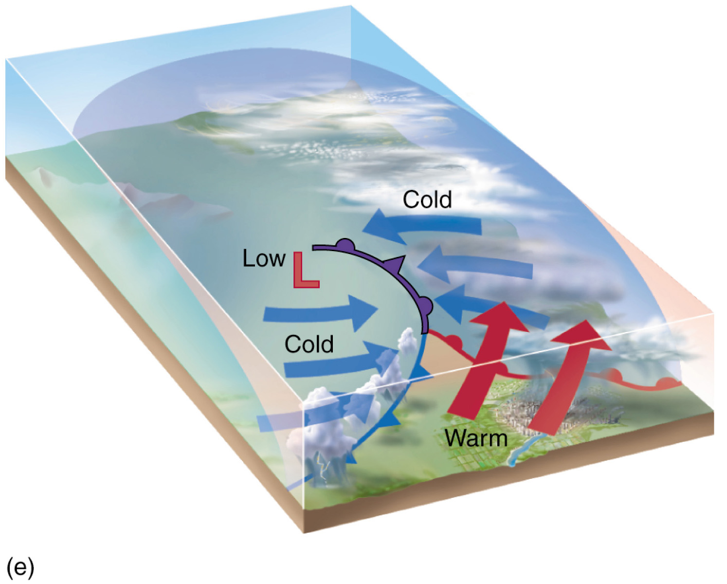
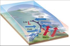
- Further, the air masses themselves moderate from surface influences.
|
|
4
|
- Migrations of cP air induce colder, drier conditions over affected
areas.
- As cP air migrates toward lower latitudes, it warms from beneath.
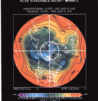
- As it warms, moisture capacity increases while stability decreases.
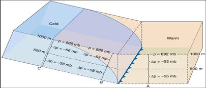
|
|
5
|
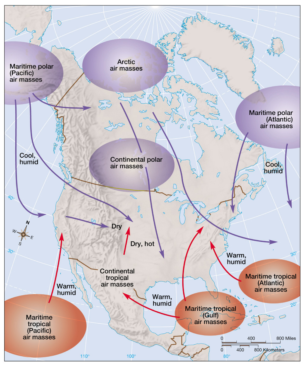
- The areas of the globe where air masses from are called source regions.
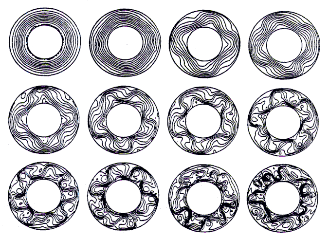
- A source region must have certain
temperature and humidity properties that can remain fixed for a
substantial length of time to affect air masses above it.
- Air mass source regions occur
only in the high or low latitudes; middle latitudes are too variable.
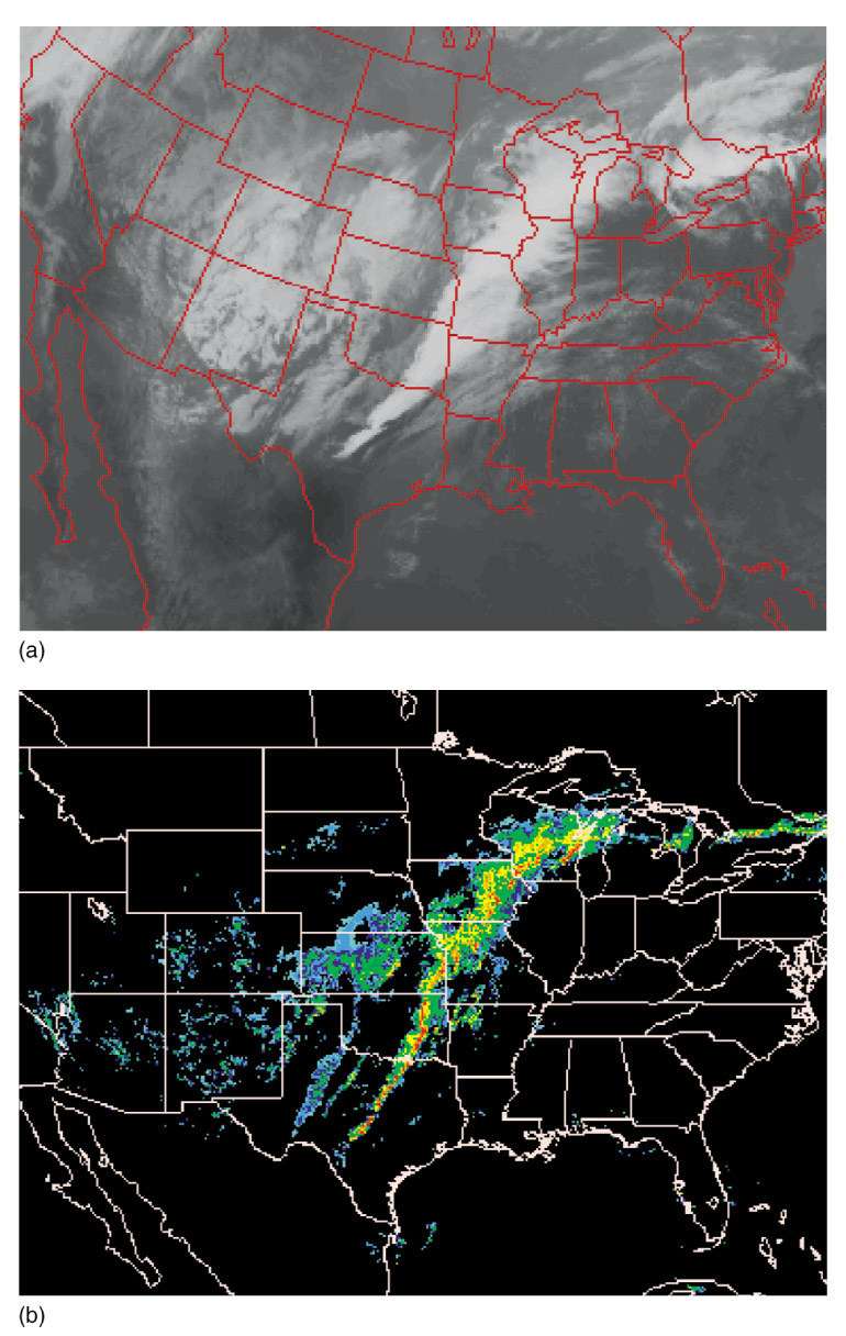
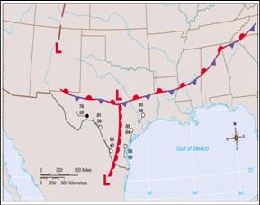
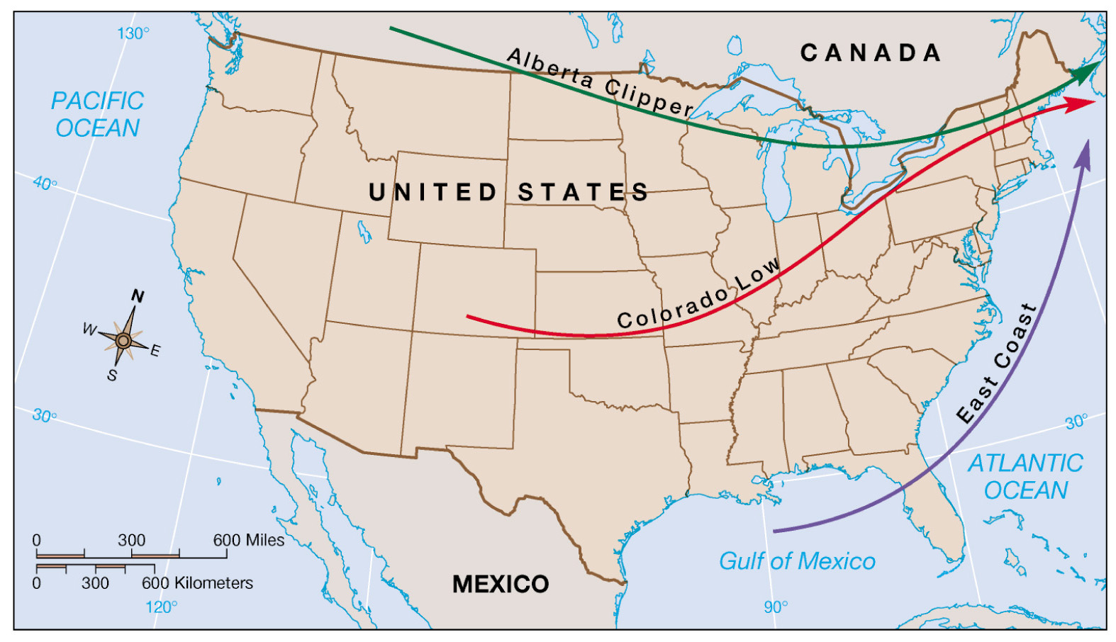
|
|
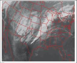
6
|
- Air masses are classified
according to the temperature and moisture characteristics of their
source regions.
- Bases on moisture content:
continental (dry) and maritime (moist)
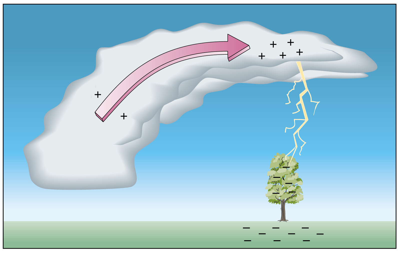
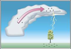
- Based on temperature: tropical
(warm), polar (cold), arctic (extremely cold).
- Naming convention for air masses:
A small letter (c, m) indicates the moist content followed by a capital
letter (T, P, A) to represent temperature.
|
|
7
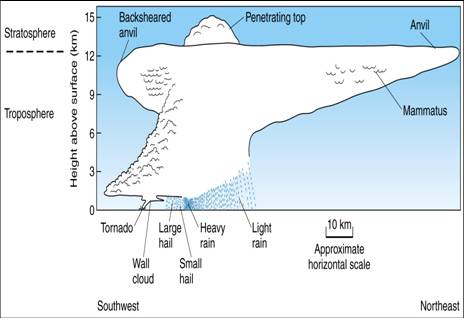
|
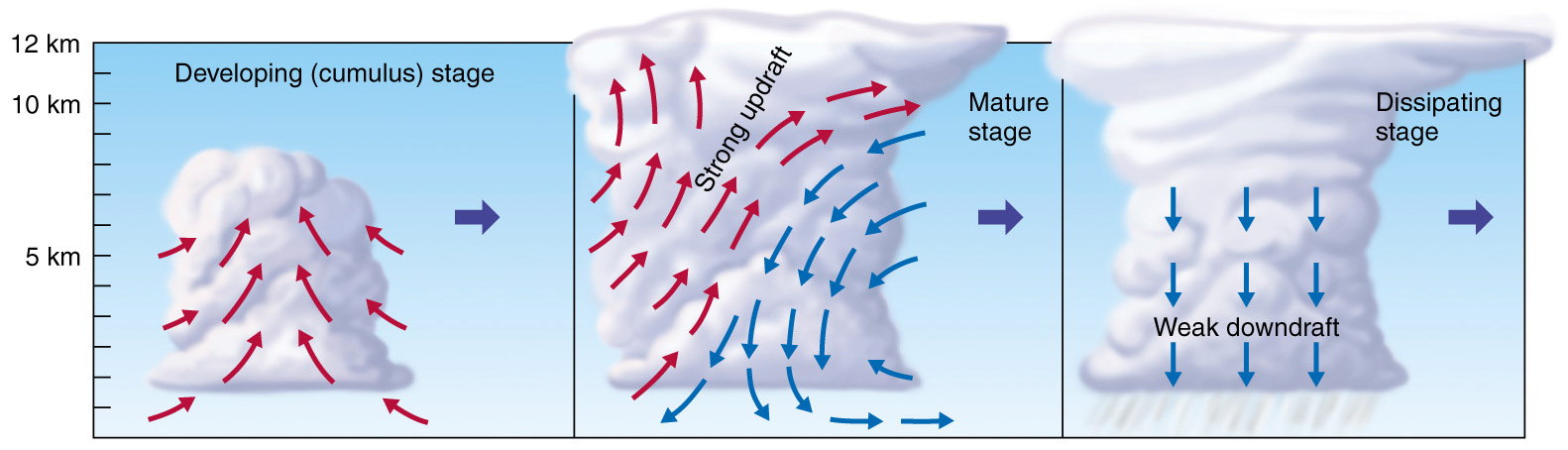
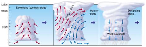
- Theoretically, there should be 6
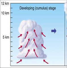
types of air masses (2 moisture types x 3 temperature types).
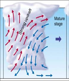
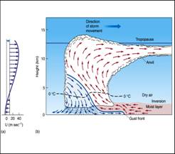
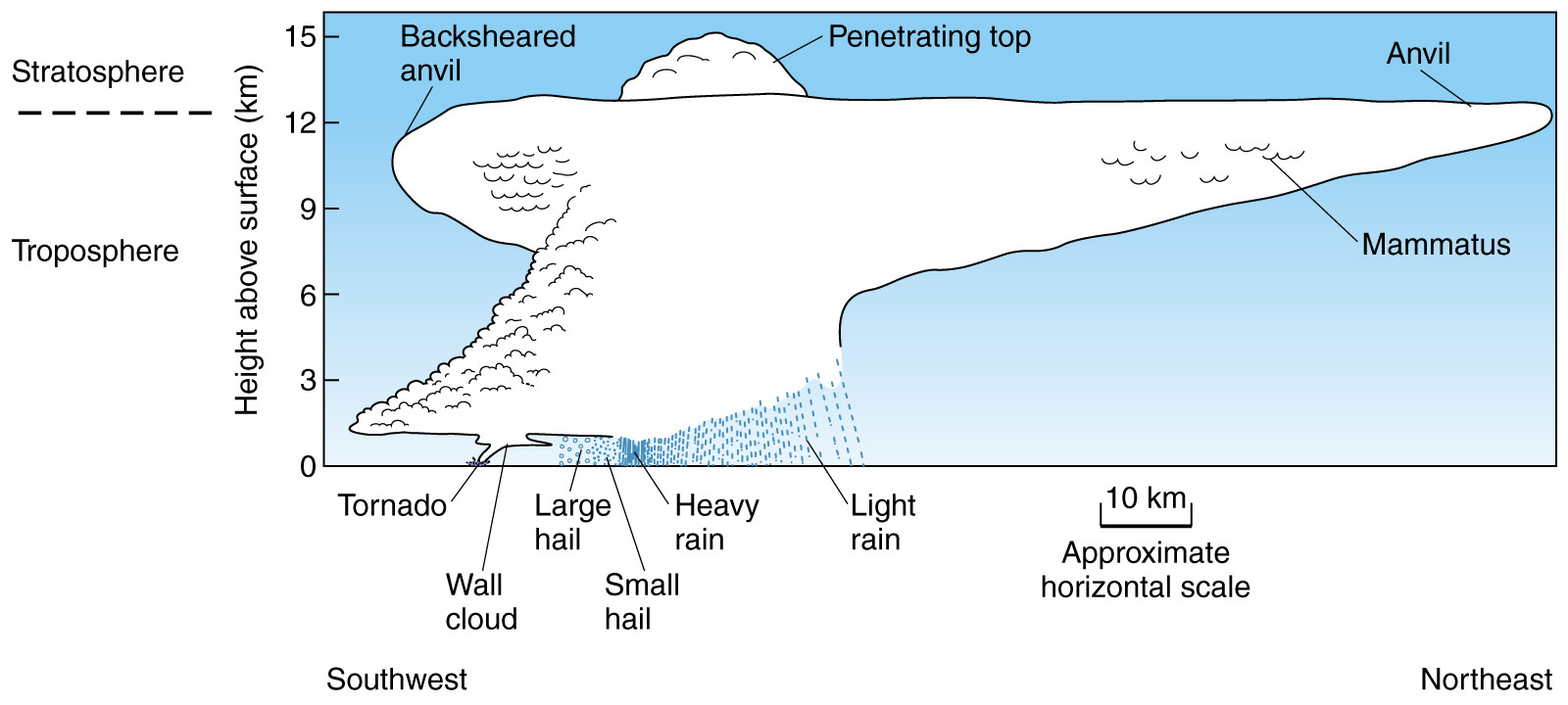
- But mA-type (maritime Arctic)
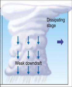
does not exist.
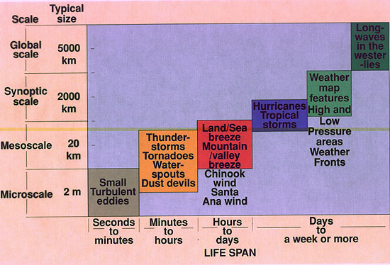
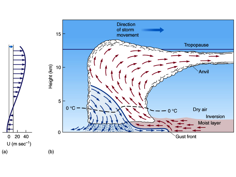
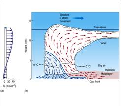
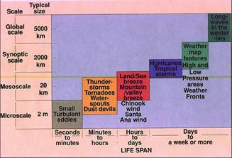
- cA: continental Arctic
- cP: continental Polar
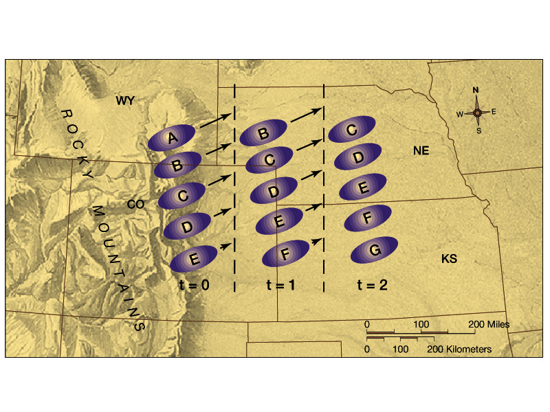
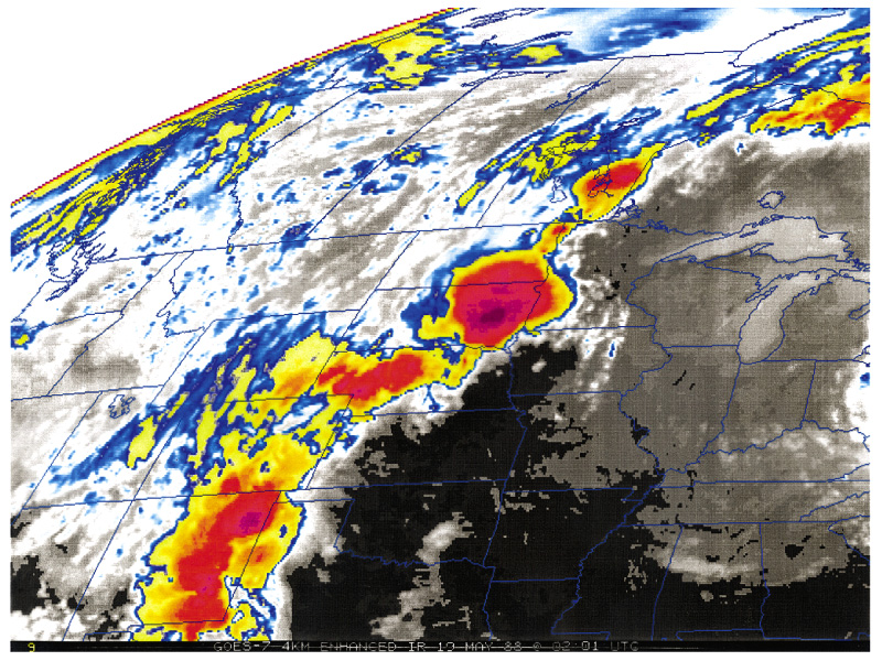
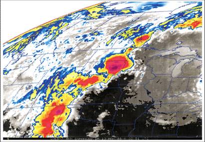
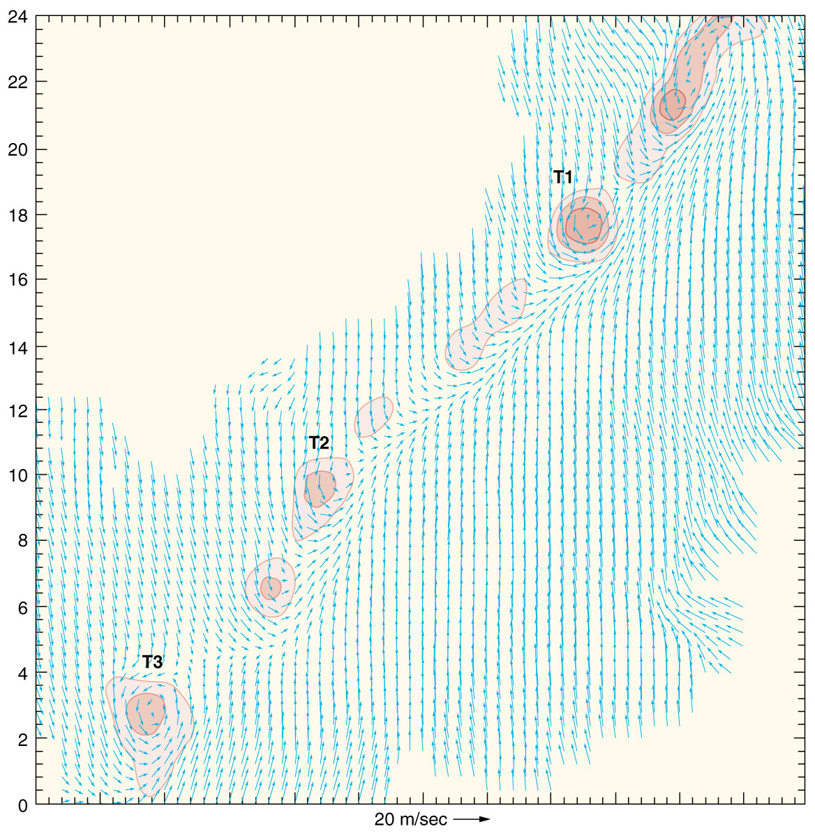
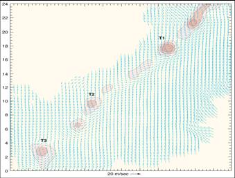
- cT: continental Tropical
- mP: maritime Polar
- mT: maritime Tropical
|
|
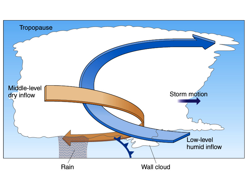
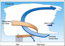
8
|
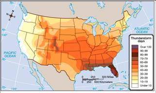
- Continental Polar air masses form
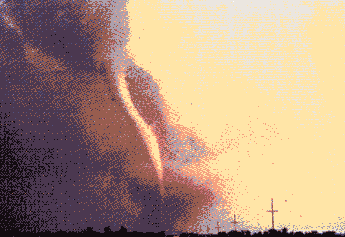
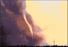
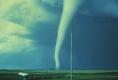
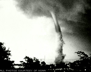
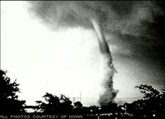
over large, high-latitude land masses, such as northern Canada or
Siberia.
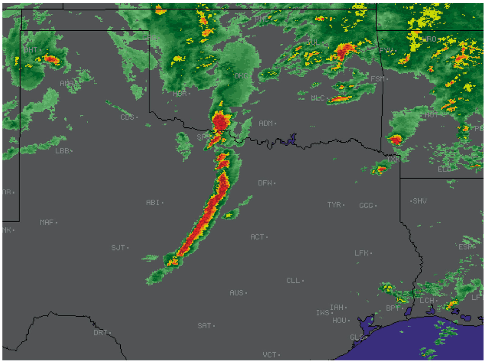
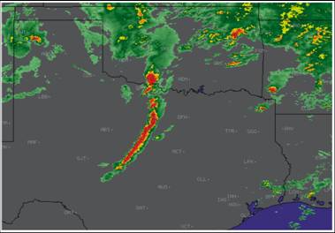
- cP air masses are cold and
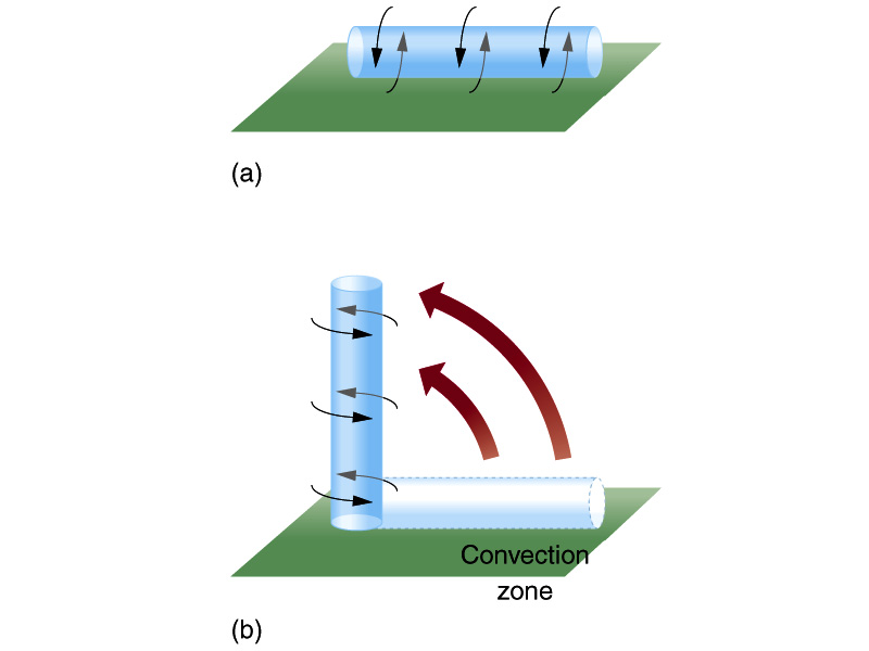
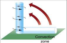
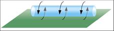
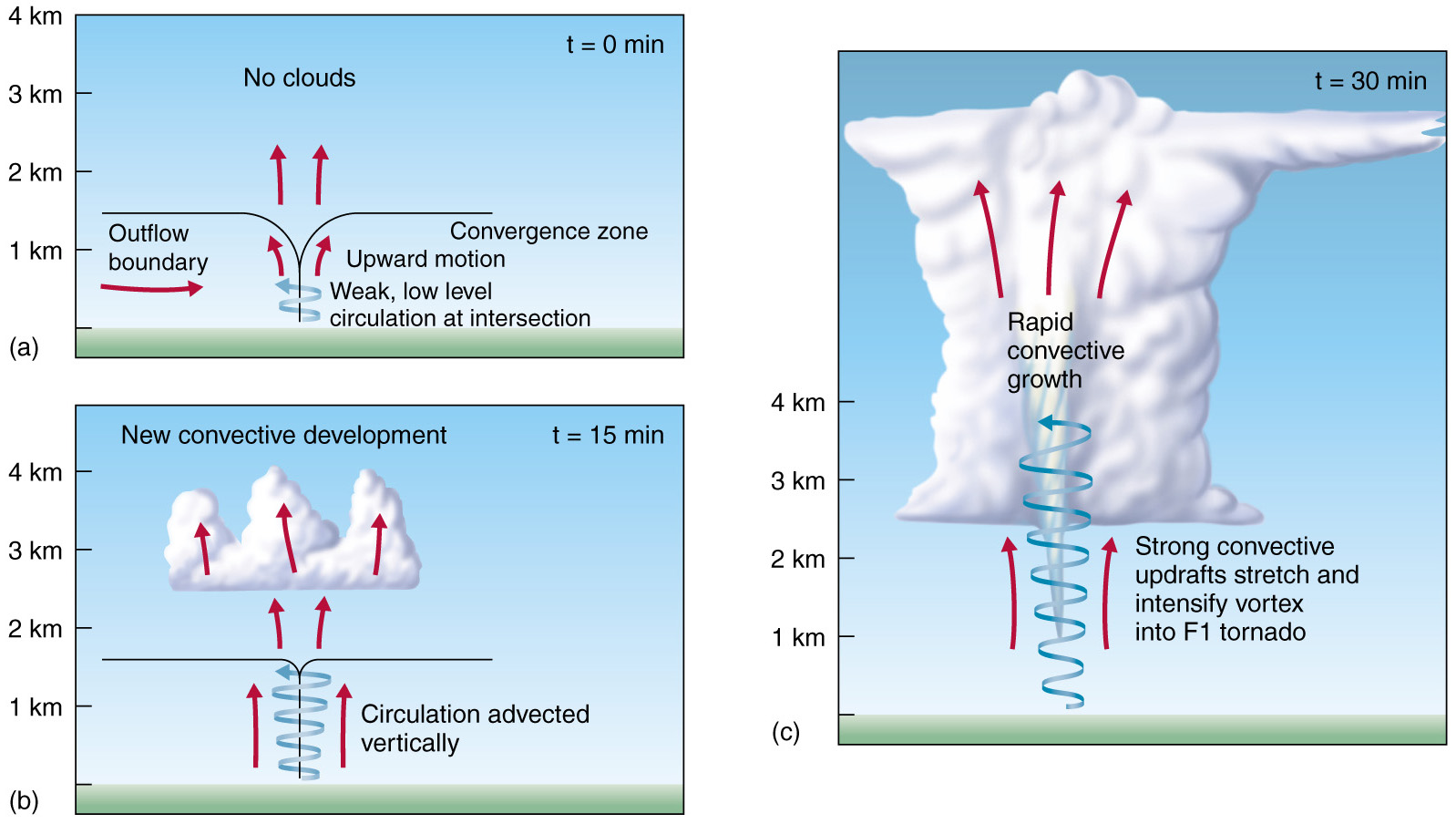
extremely dry.
- Wintertime cooling over these
land areas cause the atmosphere to become very stable (even inversion).
- The combination of dry and stable
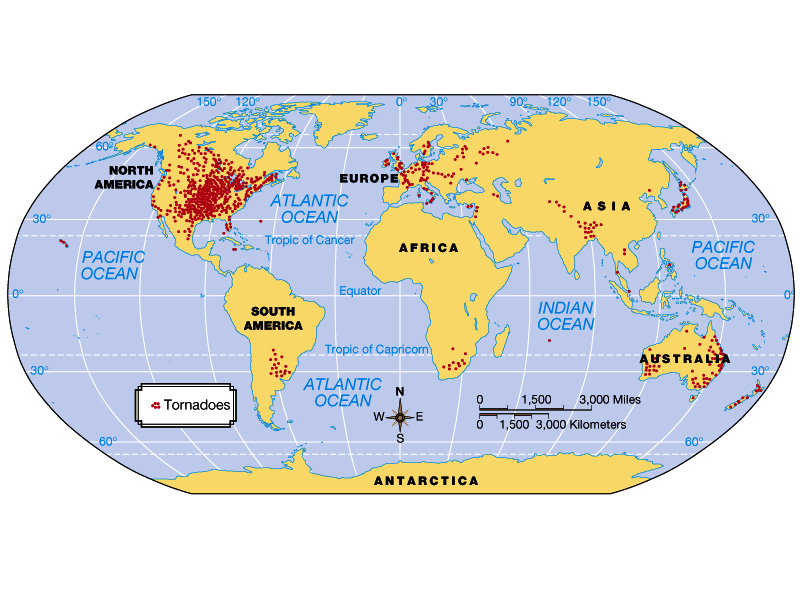
conditions ensure that few if any clouds form over a cP source region.
- Summer cP air masses are similar
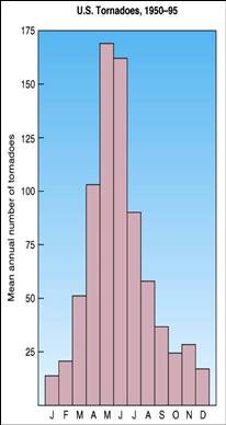
to winter cP, but much less extreme and remain at higher latitudes.
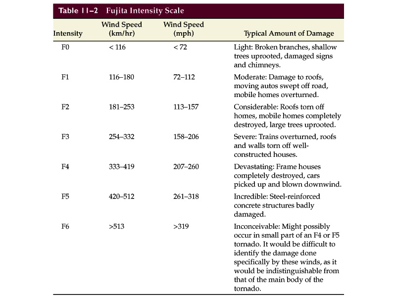
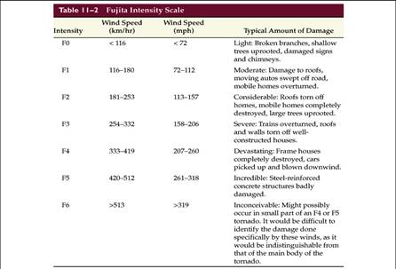
|
|
9
|
- Continental Arctic (cA) air
represents extremely cold and dry conditions as, due to its temperature,
it contains very little water vapor.
- The boundary between cA and cP
air is the shallow (~1-2 km) arctic front.
- cA air masses can extend as far southward as the Canadian-United State.
|
|
10
|
- Mainly a summertime phenomenon exclusive to the desert southwest of the
U.S. and northern Mexico.
- Characteristically hot and very dry.
- Very unstable, yet clear conditions predominate due to a lack of water
vapor.
- Thunderstorms may occur when
moisture advection occurs or when air is forced orographically.
|
|
11
|
- Maritime polar air masses form
over upper latitude oceanic regions and are cool and moist.
- mP air masses form over high-latitude ocean as cP air masses move out
from the interior of continents. (i.e., cP à mP).
- Oceans add heat and moisture into the dry and cold cP air masses.
- Along the west coast of the U.S., mP air affects regions during winter
and may be present before mid-latitude cyclones advect over the
continent.
- Along the east coast, mP air typically affects regions after cyclone
passage as the mP air wraps around the area of low pressure.
|
|
12
|
- Form over low latitude oceans and as such are very warm, humid, and
unstable.
- mT air masses from Atlantic and Gulf of Mexico is the primary source
region for the eastern U.S.
- As air advects over the warm continent in summer the high humidity and
high heat occasionally combine to dangerous levels.
- mT air masses have an enormous influence on the southwestern U.S,
particularly in summer.
|
|
13
|
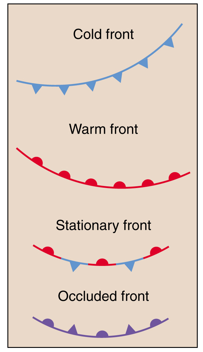
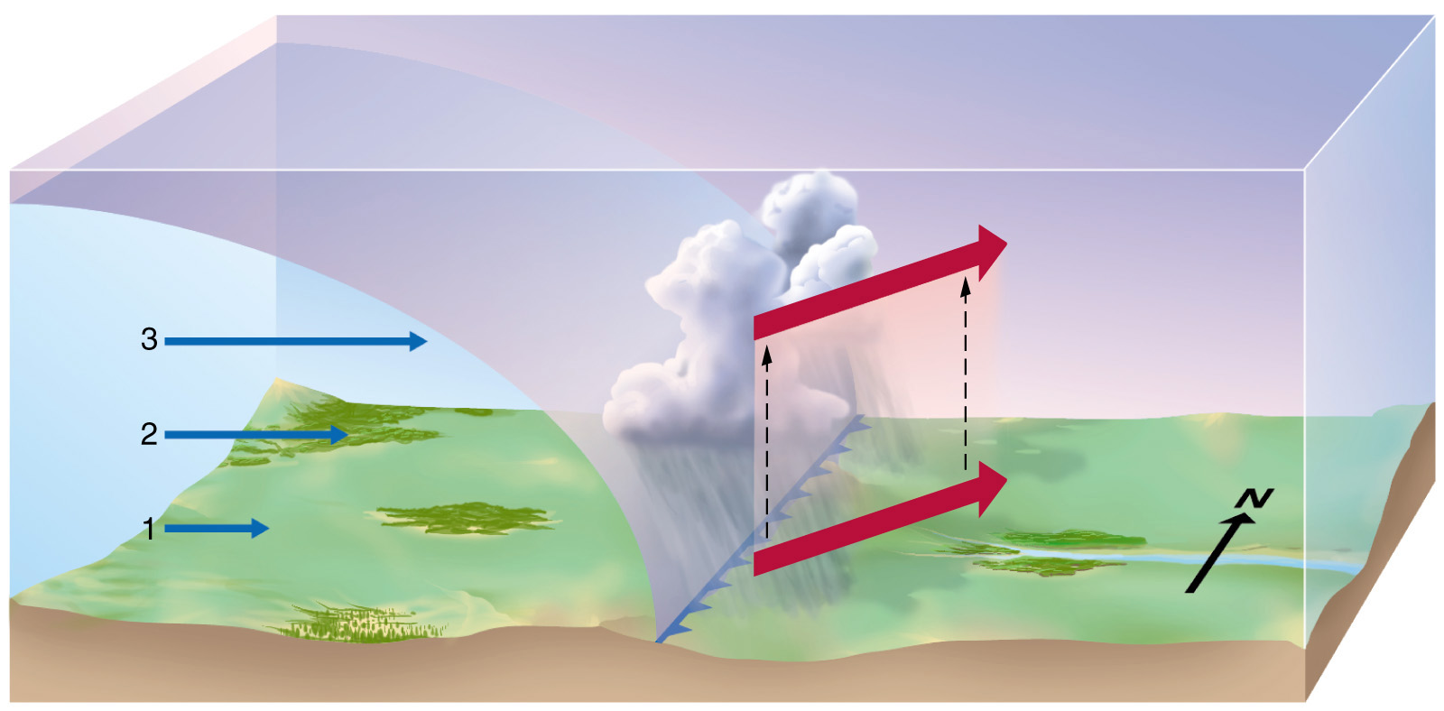
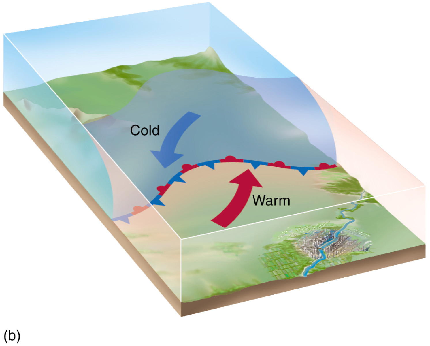
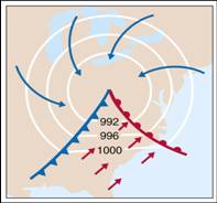
- Fronts separate air masses and bring about changes in temperature and
humidity as one air mass is replaced by another.
- There are four general types of fronts associated with mid-latitude
cyclones with the name reflective of the advancing air mass.
|
|
14
|
- Cold fronts form when cold air displaces warm air.
- Indicative of heavy precipitation events, rainfall or snow, combined
with rapid temperature drops.
- Steep front slope, typically 1:100.
- Moving faster, up to 50 km/hr (30 mph).
- Northwesterly winds behind a cold front, and southwesterly in ahead of
the front.
|
|
15
|
|
|
16
|
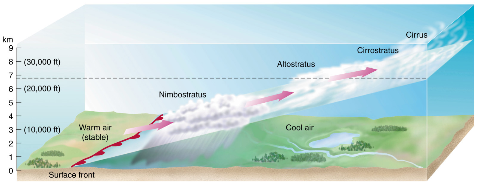
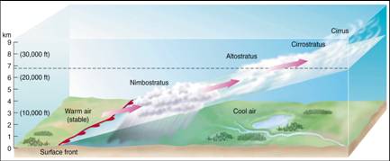
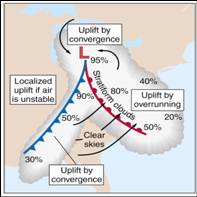
- Created when warm air displaces colder air.
- Shallow horizontal stratus clouds and light precipitation.
- Frontal fogs may occur as falling raindrops evaporate in the colder air
near the surface. Sleet and freezing rain may also formed.
- Half the slope of cold fronts, typically (1:200).
- Moving slower, about 20 km/hr (12 mph).
|
|
17
|
|
|
18
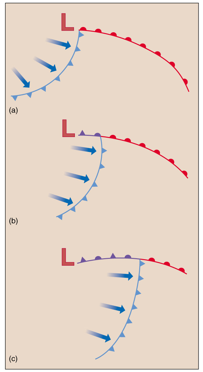
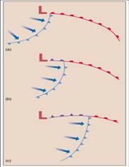
|
- When two unlike air masses remain side by side, with neither encroaching
upon the other, a stationary front exists.
- Fronts may slowly migrate and warmer air is displaced above colder.
- Fronts sloping over the cold air.
|
|
19
|
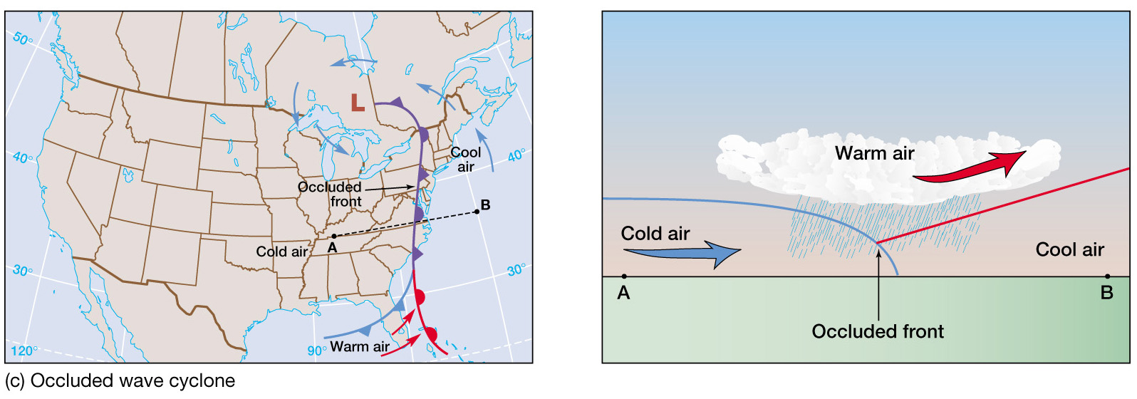
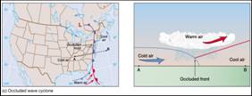
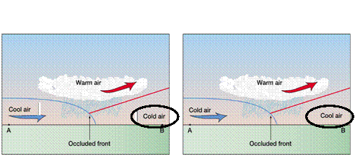
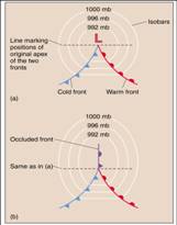
- Occlusion: the warm air is cut off from the surface by the meeting of
two fronts.
- Usually, a fast-moving cold front catches a slow-moving warm front.
- A cold-type occlusion: eastern half of the continent where a cold front
associated with cP air meets a warm front with mP air ahead.
- A warm-type occlusion: western edges of continents where the cold front,
associated with mP air, invades an area in which colder cP air is
entrenched.
|
|
20
|
|
|
21
|
|
|
22
|
- Because humidity is an important
determinant of air density, air masses with similar temperatures but
strong humidity gradients will act as fronts.
- Boundaries between dry and moister air are called drylines.
- They frequently occur throughout the Great Plains and are an important
contributor to storm development.
|
|
23
|
|
|
24
|
|
|
25
|
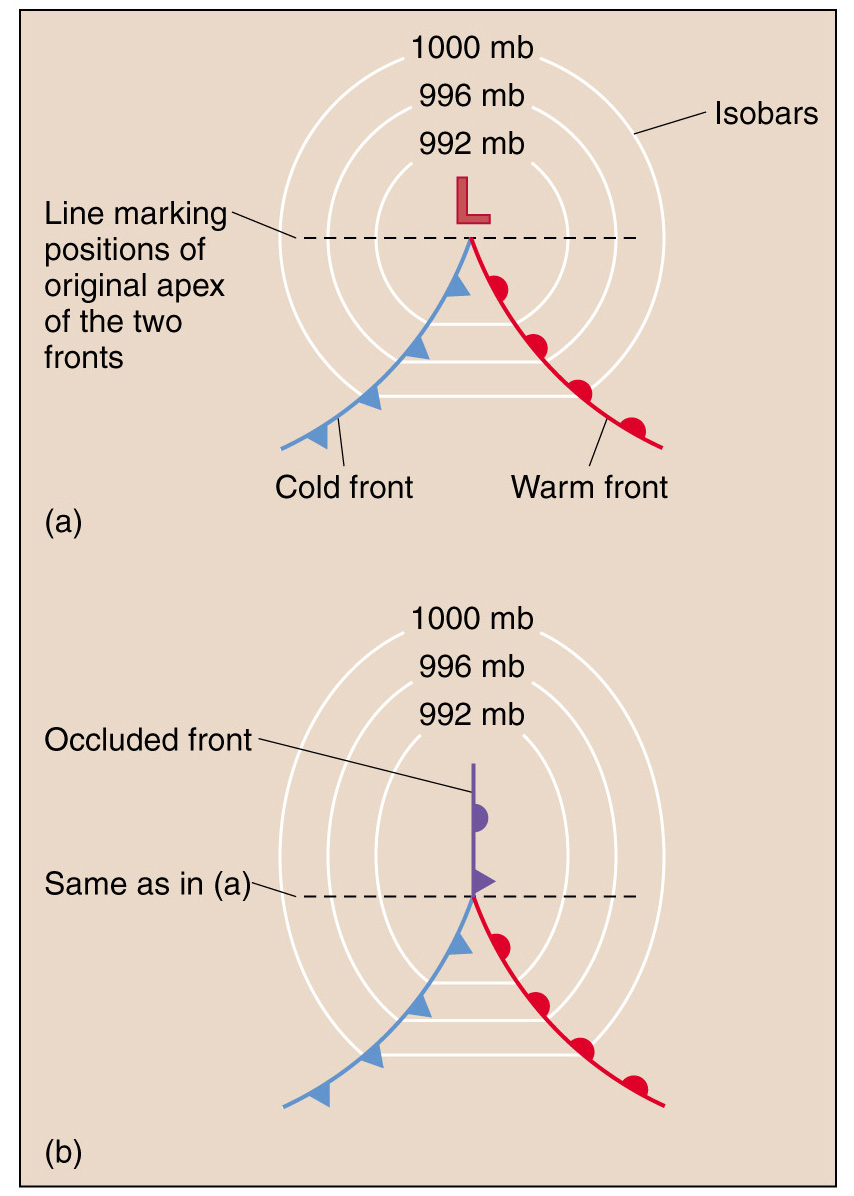
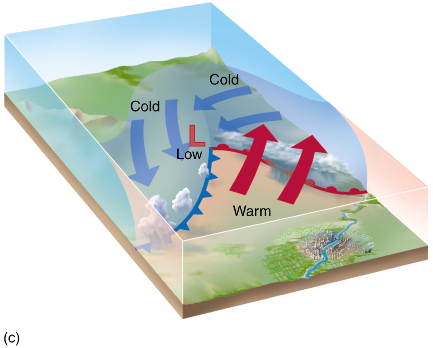
- Mid-latitude cyclones form along
a boundary separating polar air from warmer air to the south.
- These cyclones are large-scale
systems that typically travels eastward over great distance and bring
precipitations over wide areas.
- Lasting a week or more.
|
|
26
|
- Bjerknes, the founder of the
Bergen school of meteorology, developed polar front theory during WWI to
describe the formation, growth, and dissipation of mid-latitude
cyclones.
|
|
27
|
- Cyclogenesis
- Mature Cyclone
- Occlusion
|
|
28
|
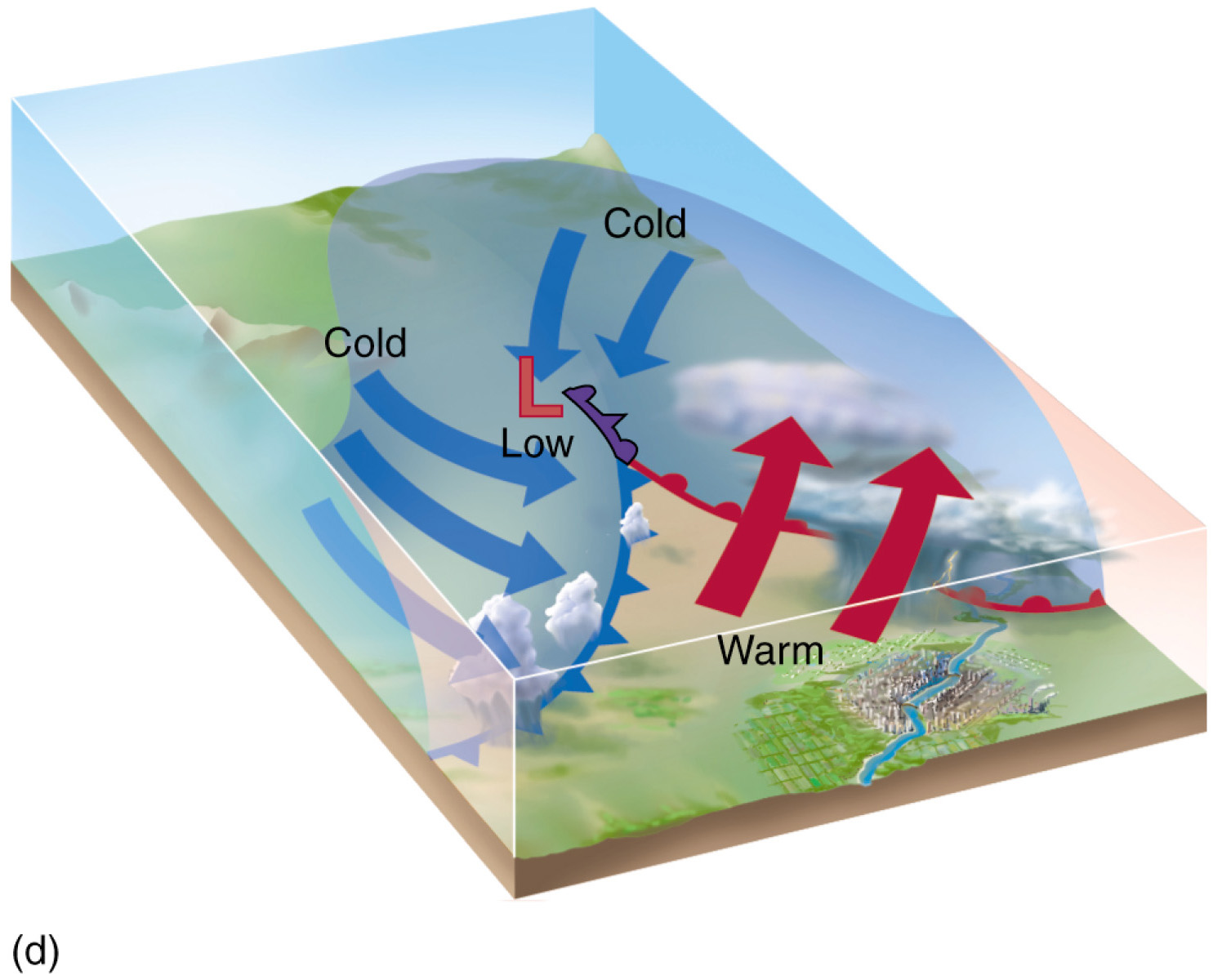
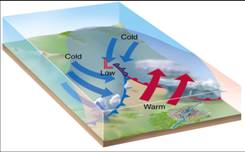
- Cyclogenesis typically begins along the polar front but may initiate
elsewhere, such as in the lee of mountains.
- Minor perturbations occur along the boundary separating colder polar
easterlies from warmer westerlies.
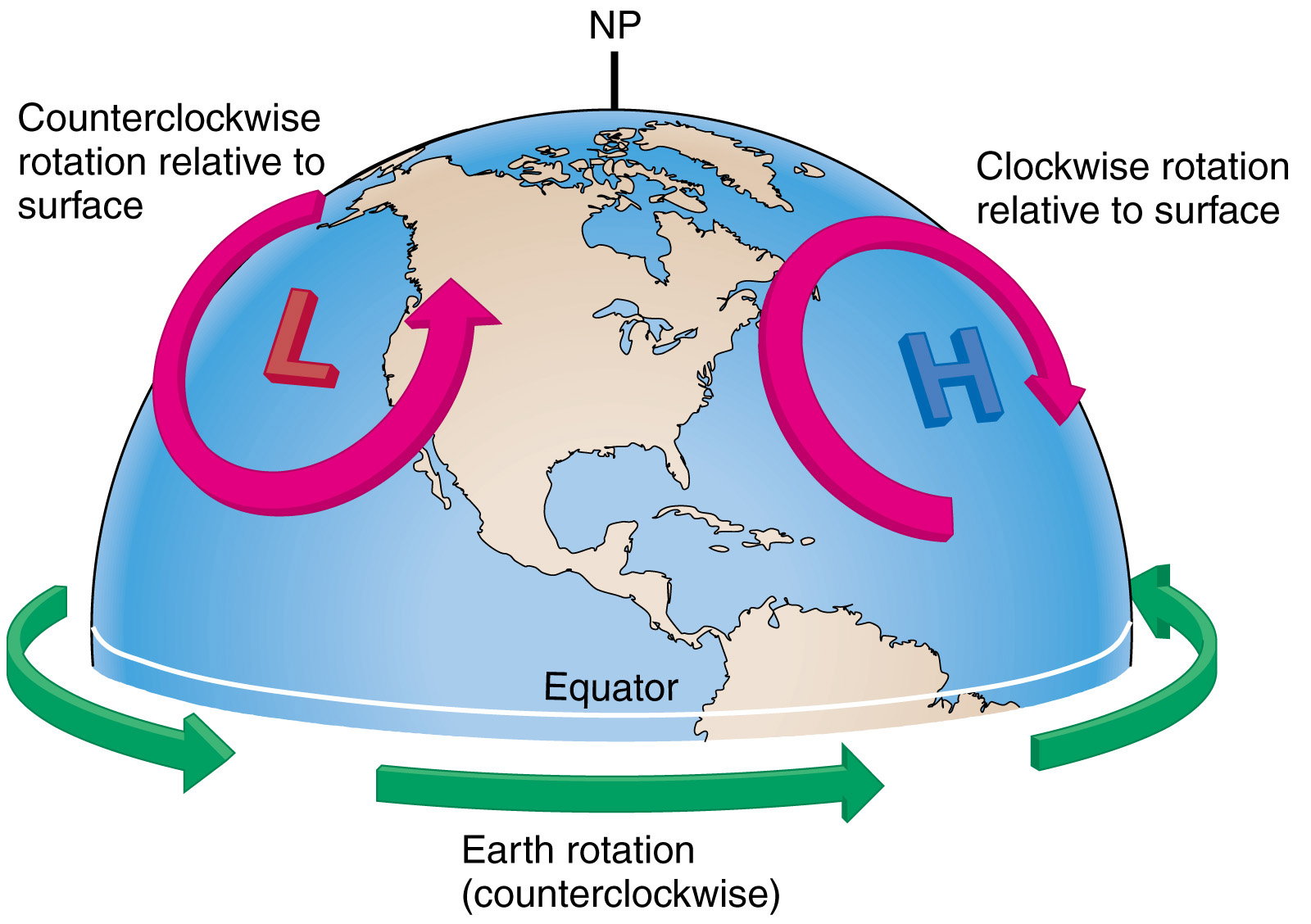
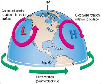
- A low pressure area forms and due to the counterclockwise flow (N.H.)
colder air migrates equatorward behind a developing cold front.
- Warmer air moves poleward along a developing warm front (east of the
system).
- Clouds and precipitation occur in association with converging winds of
the low pressure center and along the developing fronts.
|
|
29
|
|
|
30
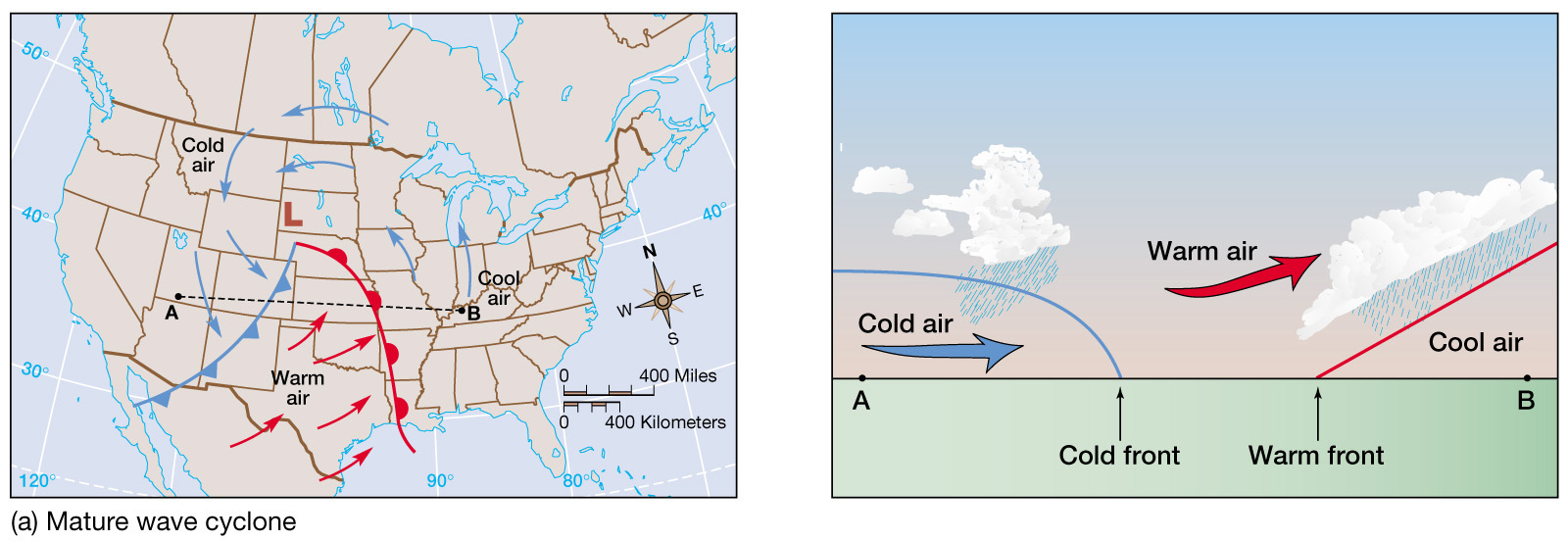
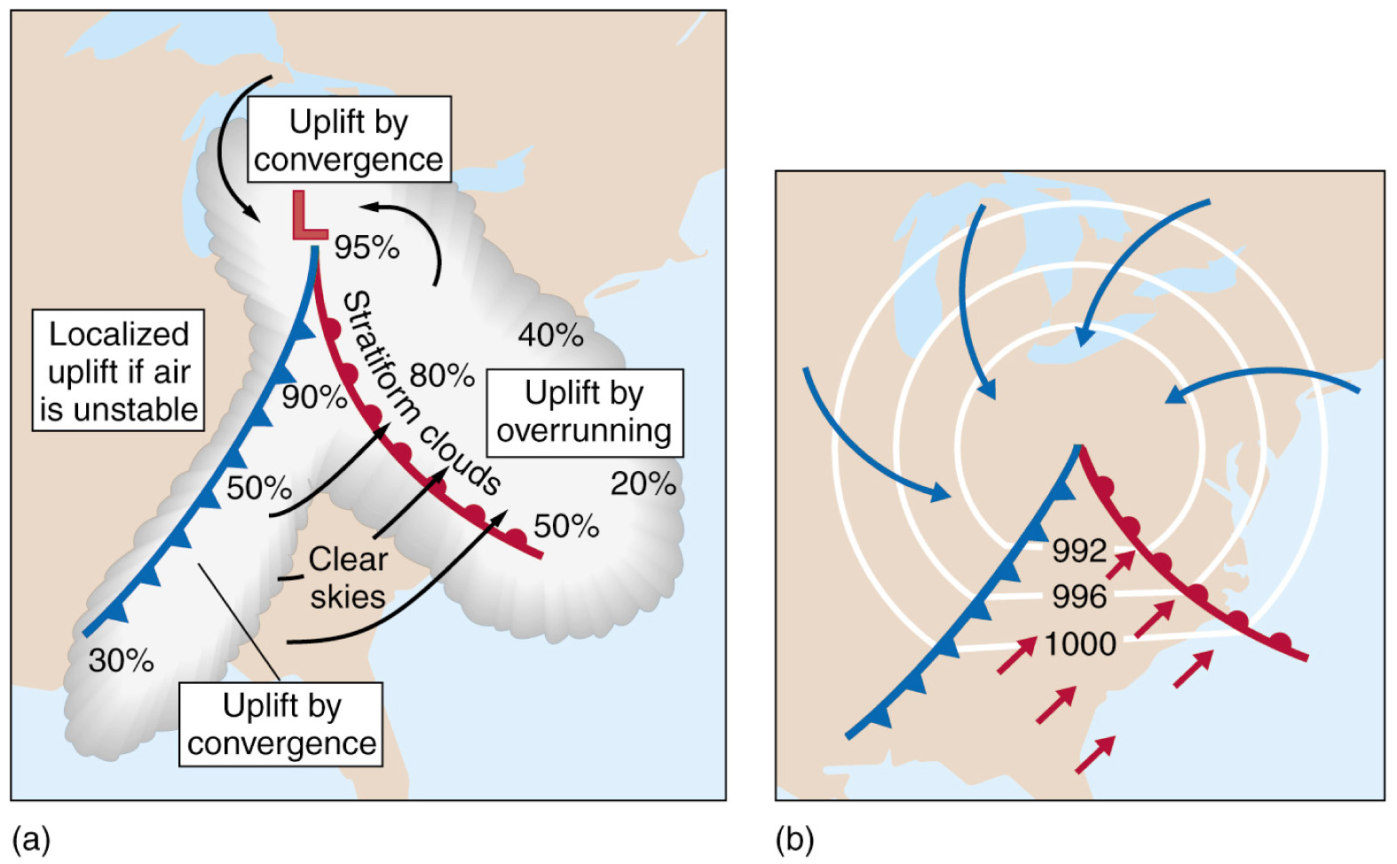
|
- Well-developed fronts circulating about a deep low pressure center
characterize a mature mid-latitude cyclone.
- Heavy precipitation stems from cumulus development in association with
the cold front.
- Lighter precipitation is associated with stratus clouds of the warm
front.
- Isobars close the low and are typically kinked in relation to the fronts
due to steep temperature gradients.
|
|
31
|
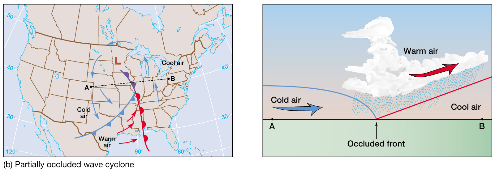
- When the cold front joins the
warm front, closing off the warm sector, surface temperature differences
are minimized.
- The system is in occlusion, the end of the system’s life cycle.
|
|
32
|
|
|
33
|
|
|
34
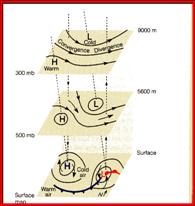
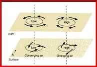
|
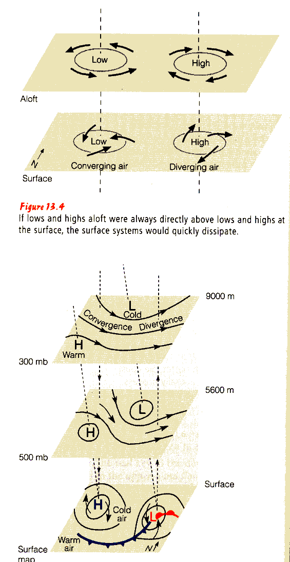
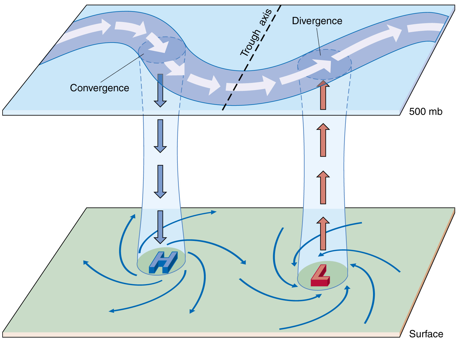
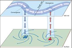
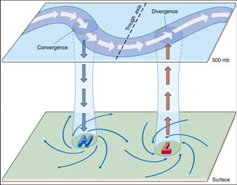
- Increasing vorticity in the zone between a ridge and a trough leads to
upper air convergence and sinking motions through the atmosphere, which
supports surface high pressure areas.
- Decreasing vorticity in the zone between a trough and a ridge leads to
upper air divergence and rising motions through the atmosphere, which
supports surface low pressure areas.
|
|
35
|
|
|
36
|
- The movement of surface systems
can be predicted by the 500 mb pattern.
- The surface systems move in about the same direction as the 500 mb flow,
at about 1/2 the speed.
- Upper-level winds are about twice as strong in winter than summer.
- This results in stronger pressure gradients (and winds), resulting in
stronger and more rapidly moving surface cyclones.
|
|
37
|
- Upper air troughs develop behind
surface cold fronts with the vertical pressure differences proportional
to horizontal temperature and pressure differences.
- This is due to density considerations associated with the cold air.
- Such interactions also relate to warm fronts and the upper atmosphere.
|
|
38
|
- Carl Rossby mathematically expressed relationships between mid-latitude
cyclones and the upper air during WWII.
- Mid-latitude cyclones are a large-scale waves (now called Rossby waves)
that grow from the “baroclinic” instabiloity associated with the
north-south temperature differences in middle latitudes.
|
|
39
|
|
|
40
|
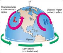
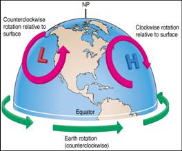
- Temperature differences between the equator and poles
- The rate of rotation of the Earth.
|
|
41
|
|
|
42
|
- The rotation of a fluid (such as
air and water) is referred to as its vorticity.
|
|
43
|
- Earth vorticity is a function solely of latitude.
- The higher the latitude, the greater the vorticity.
- Earth vorticity is zero at the equator.
|
|
44
|
|
|
45
|
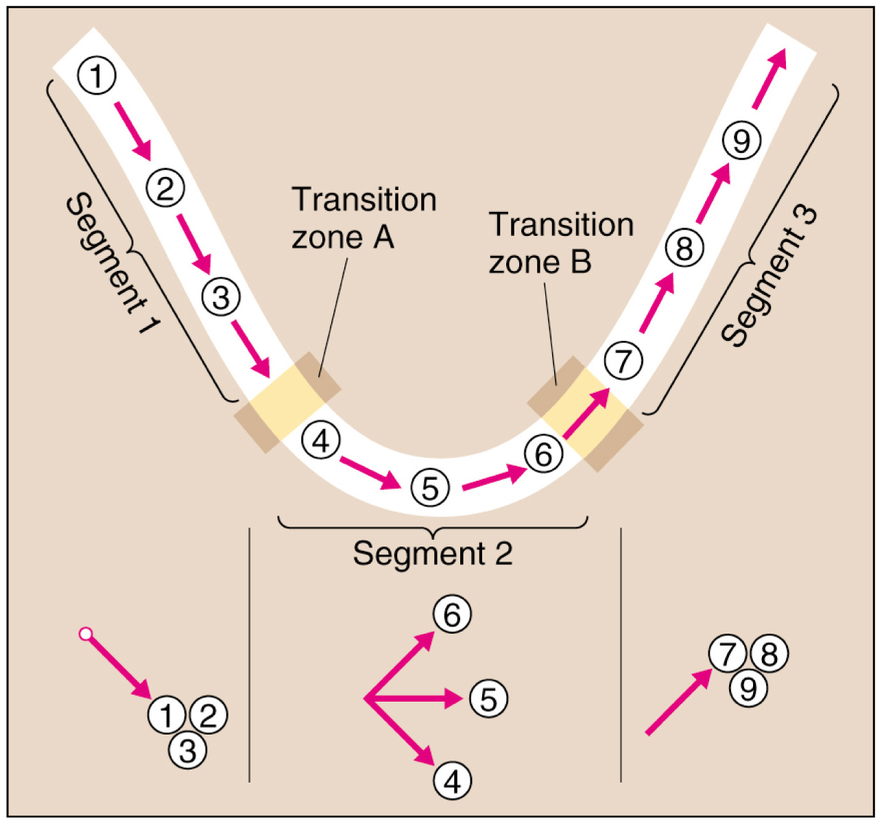
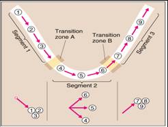
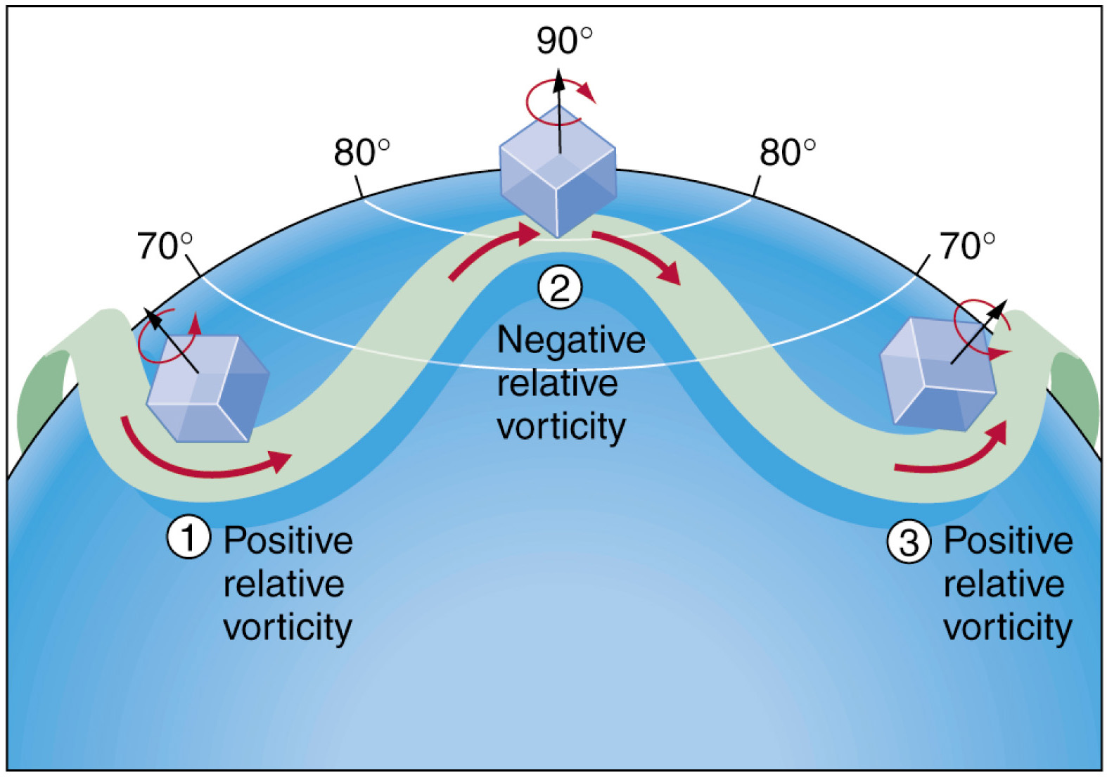
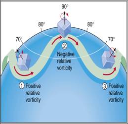
- Rossby waves are produced from
the conservation of absolute vorticity.
- As an air parcle moves northward
or southward over different latitudes, it experiences changes in Earth
(planetary) vorticity.
- In order to conserve the absolute vorticity, the air has to rotate to
produce relative vorticity.
- The rotation due to the relative
vorticity bring the air back to where it was.
|
|
46
|
|
|
47
|
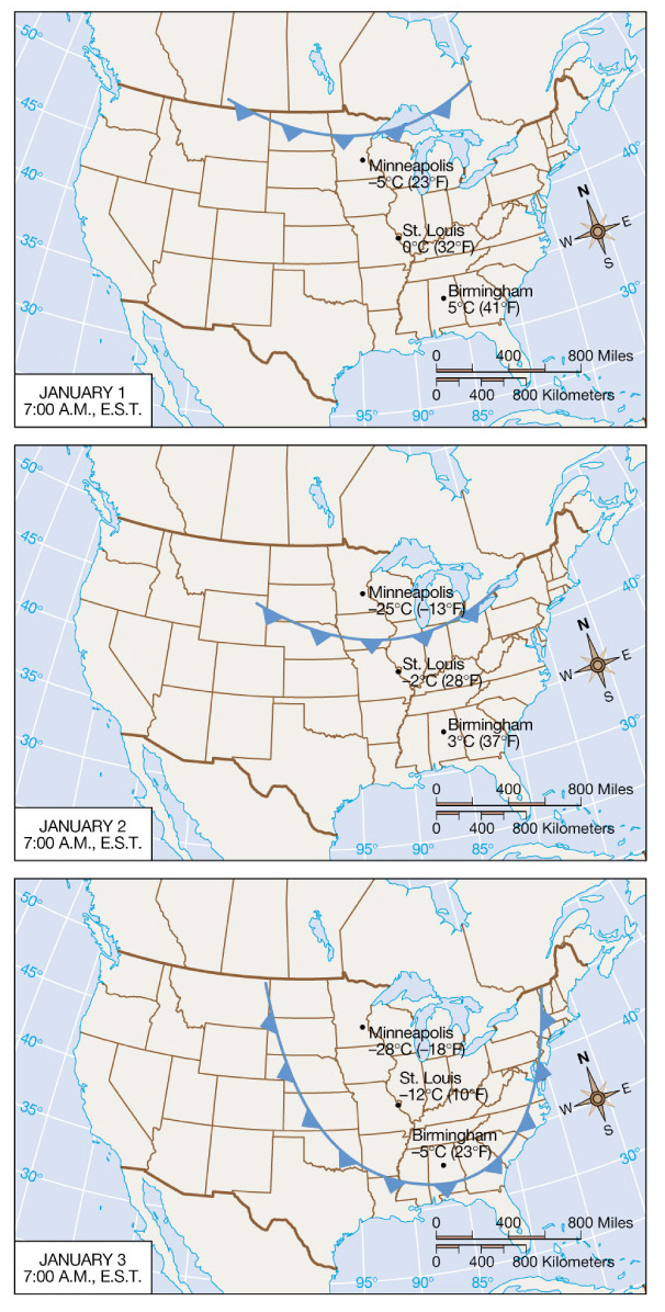
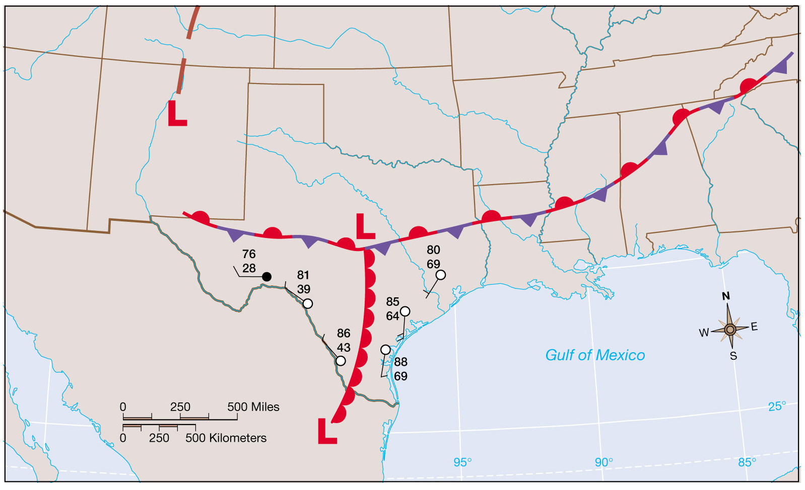
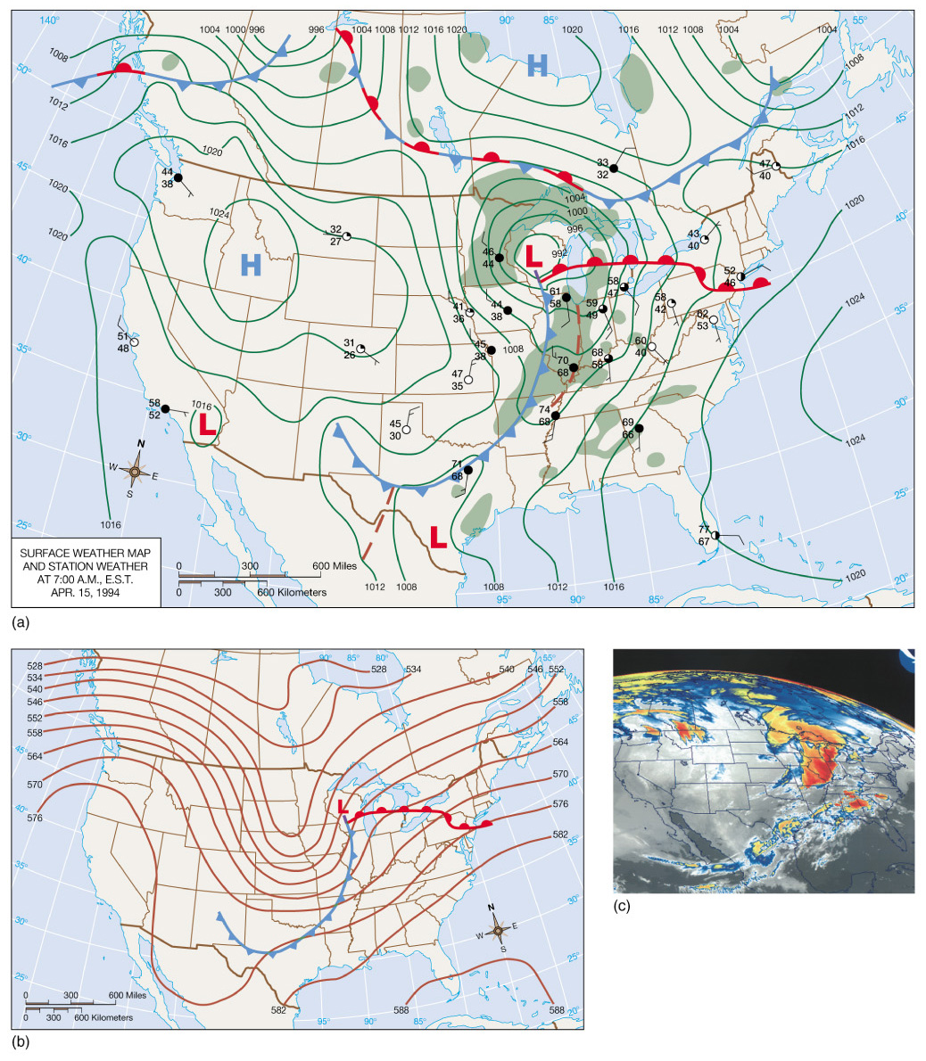
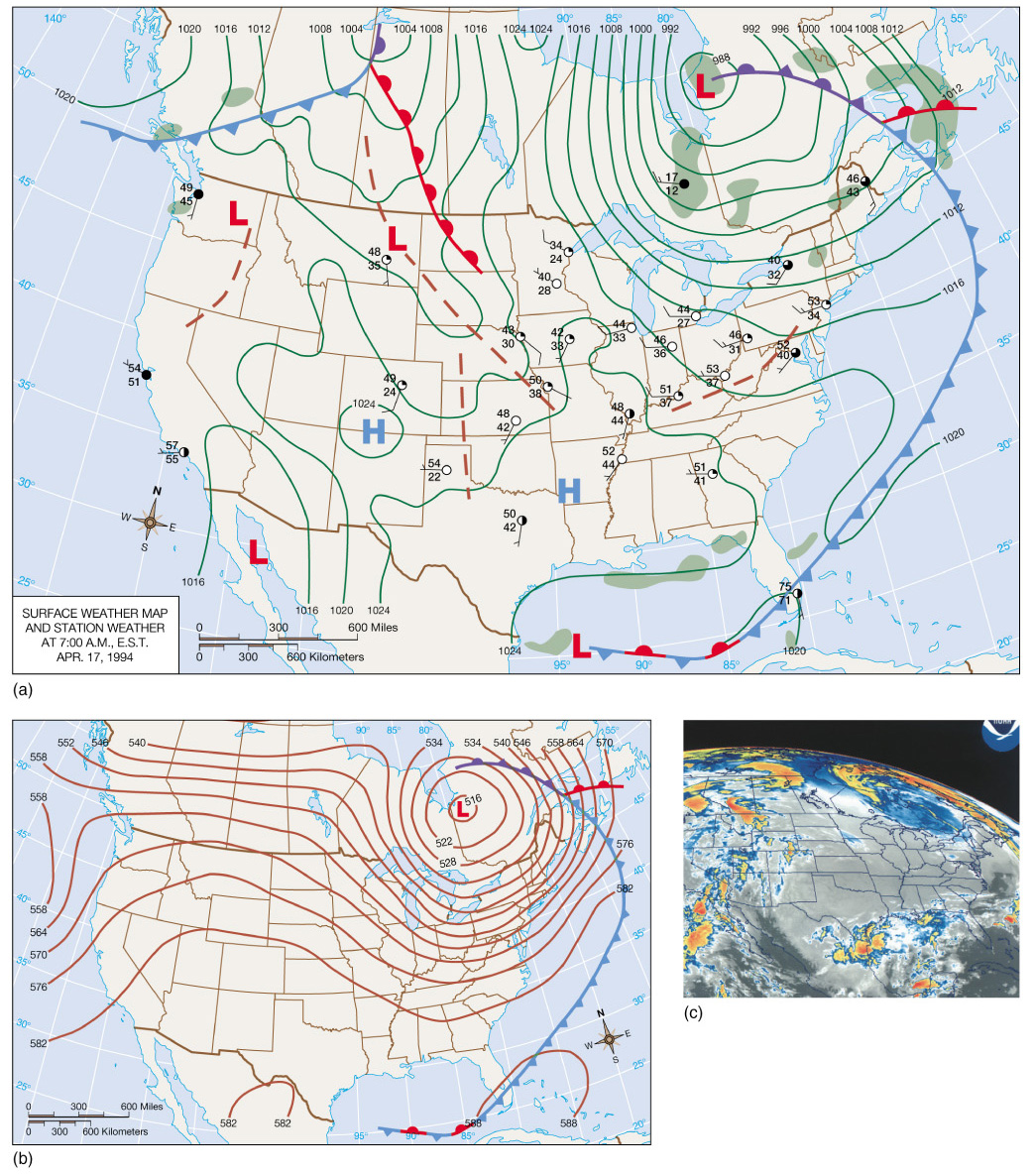
- April 16 - The northeastward movement of the storm system is seen
through a comparison of weather maps over a 24-hour period
- Occlusion occurs as the low moves over the northern Great Lakes
- In the upper air, the trough has increased in amplitude and strength
and become oriented northwest to southeast
- Isobars have closed about the low, initiating a cutoff low
|
|
48
|
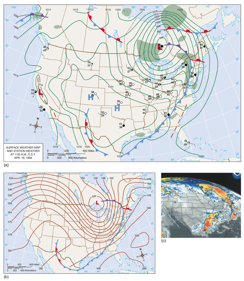
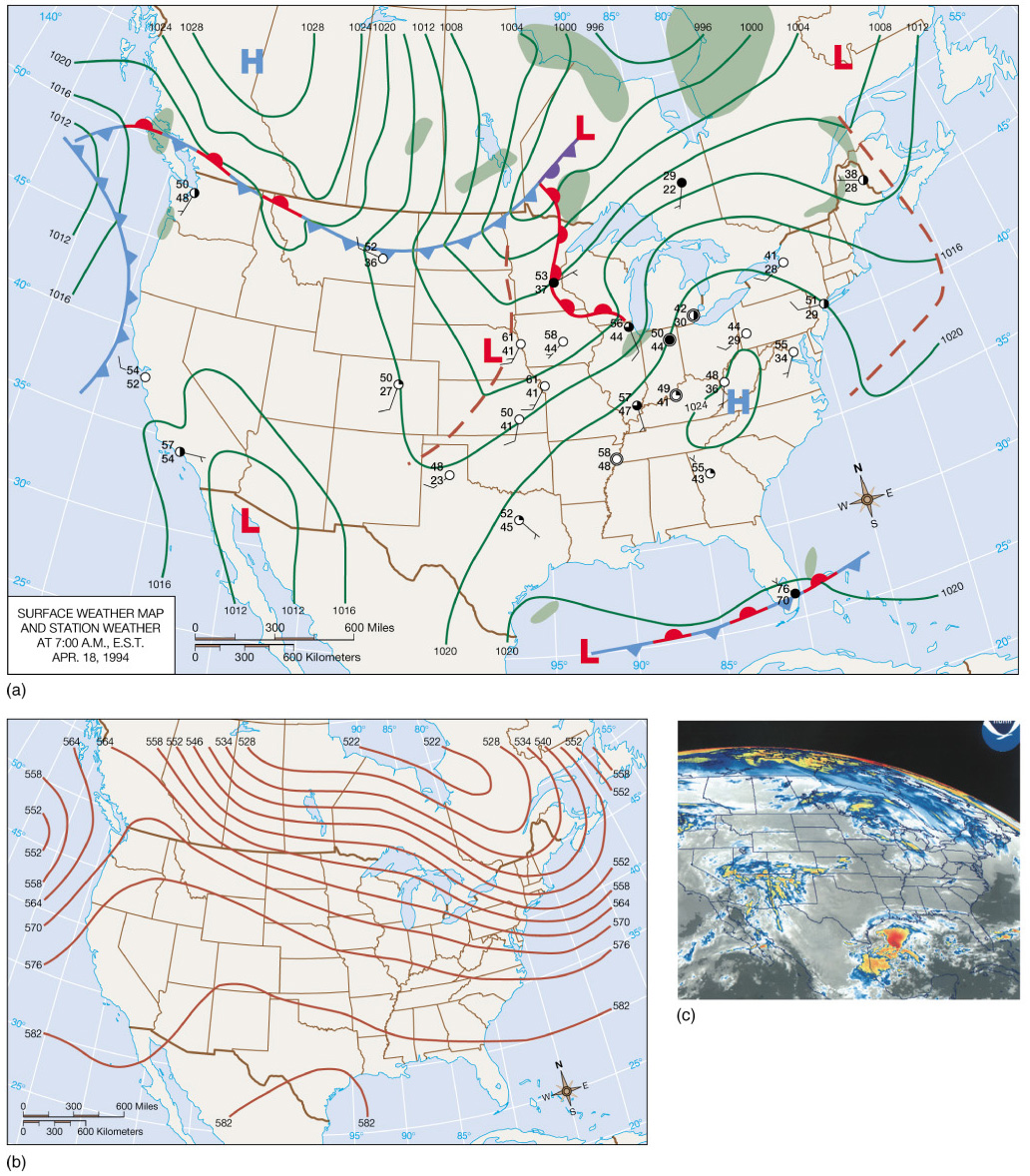
- April 17 - Continual movement towards the northeast is apparent,
although system movement has lessened
- The occlusion is now sweeping northeastward of the low, bringing
snowfall to regions to the east
- In the upper air, continued deepening is occurring in association
with the more robust cutoff low
|
|
49
|
- April 18 -The system has moved over the northwestern Atlantic Ocean,
but evidence persists on the continent in the form of widespread
precipitation
- The upper atmosphere also shows evidence of the system, with an
elongated trough pattern
|
|
50
|
- The movement of surface systems
can be predicted by the 500 mb pattern.
- The surface systems move in about the same direction as the 500 mb flow,
at about 1/2 the speed.
- Upper-level winds are about twice as strong in winter than summer.
- This results in stronger pressure gradients (and winds), resulting in
stronger and more rapidly moving surface cyclones.
|
|
51
|
|
|
52
|
|
|
53
|
|
|
54
|
- Cloud-to-Cloud Lightning
- 80% of all lightning
- Electricity discharge happens within clouds
- Causes the sky to light up uniformly (sheet lightning)
- Cloud-to-Ground Lightning
- 20% of all lightning
- Electricity discharge happens between cloud base and ground
|
|
55
|
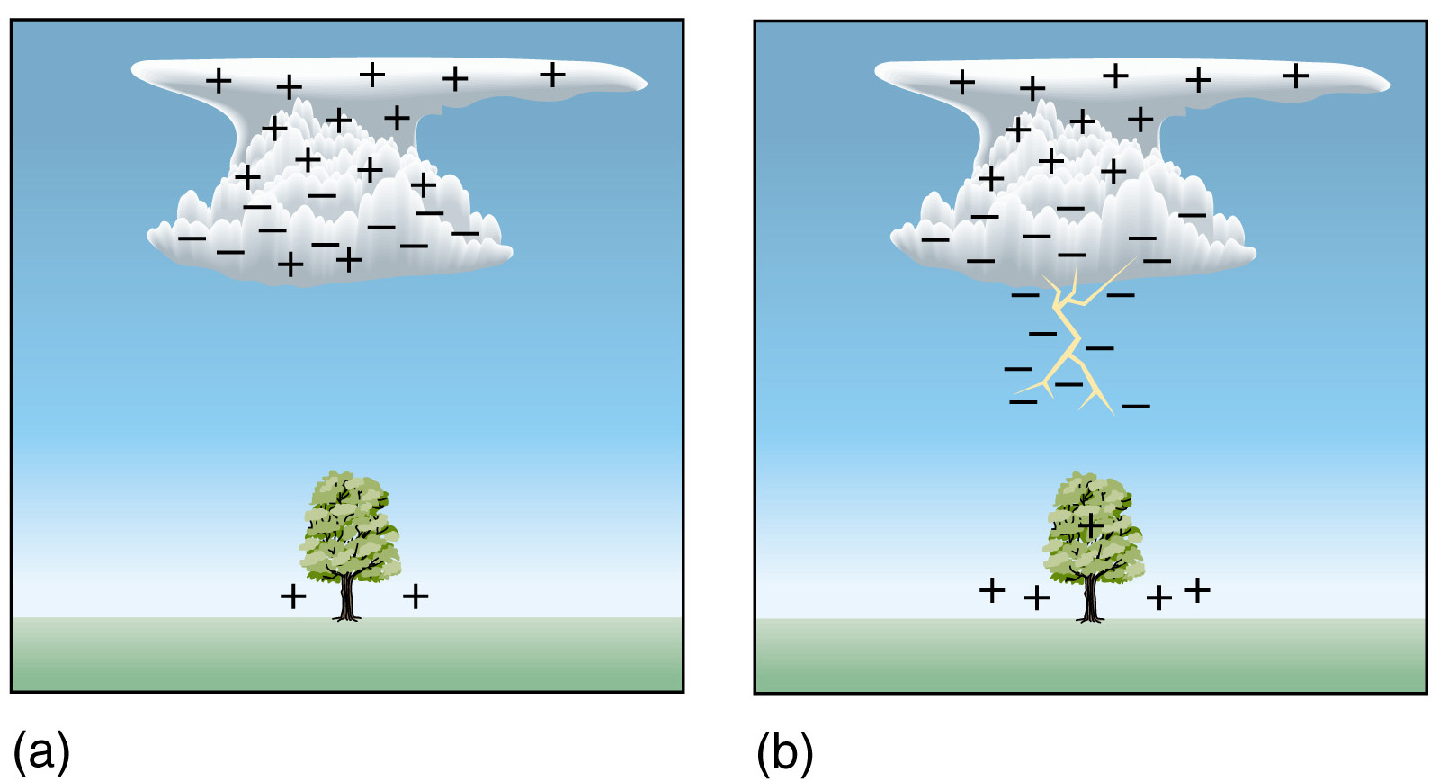
- Electrification of a cloud:
Charge Separation
- Development of a path through
which the electrons can flow
- Discharge: Lightning
|
|
56
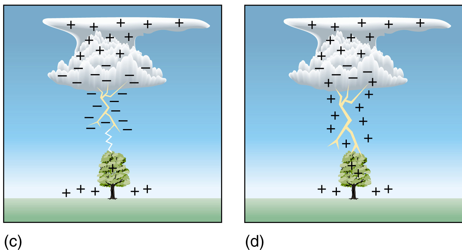
|
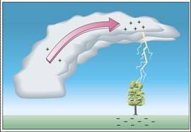
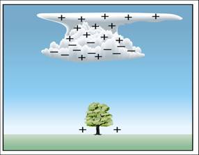
- Positive charges in the upper portions of the cloud; Negatively charges
in lower portions; Small packet of positive charges in the cloud base.
- lightning occurs only in clouds that extend above the freezing level è charge separation
is related to ice crystals.
- Lighter crystals collide with heavy hailstones in the cloud.
- The lighter crystals are positively charged and move to upper portions
of the cloud.
- The heavy hail stones are negatively charged and move to the lower
portion of the cloud.
|
|
57
|
- The negative charge at the bottom
of the cloud causes a region of the ground beneath it to become
positively charged.
- The positive charge is most dense on protruding objects, such as trees,
poles, and buildings.
|
|
58
|
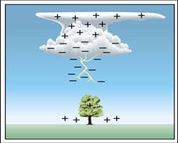
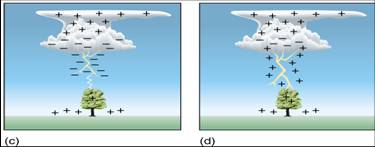
- The dry air is a good electrical insulator, so a flow of current can not
occur.
- For cloud-to-ground lightning to
occur, a stepped-leader must emanate from the cloud base.
- The leader is essentially an ionized particle chamber about 10 cm (4 in)
in diameter which forks repeatedly from a main channel.
- Each section travels about 50 m in a microsecond (a millionth of a sec).
- The sections continue until contact is made with an unlike charged area
(the ground).
|
|
59
|
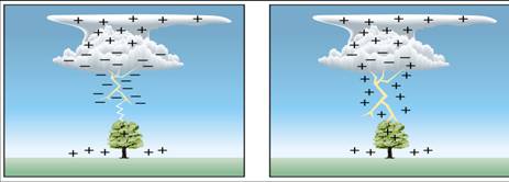
- Upon connection, electrons flow
resulting in an illuminated return stroke.
- Although the electrical current
is from the cloud to the ground (moves downward), the return stroke is
in the opposite direction (move upward).
- The upward return stroke happens so fast, our eyes can not resolve its
upward direction.
|
|
60
|
- Usually more than one stroke is
needed to neutralize all negative ions.
- Another leader, or dart leader, is initiated and a return stroke
follows.
- Dart leader moves downward faster than step leader.
- The process is repeated about 2-3 times on average.
- Individual strokes are almost impossible to detect.
- We call a combination of all strokes a lightning flash.
|
|
61
|
|
|
62
|
- Most of the lightning are
negatively charged cloud-to-positively charged ground (negative
lightning).
- But there are also positively
charged cloud-to-negatively charged ground (positive lightning).
- When high-level winds are strong, thunderstorm clouds become tilted and
produce the positive lightning.
|
|
63
|
- The lightning stroke can heat the
air through which it travels to 30,000ºC (54,000ºF), which is 5 times
hotter than the surface of sun.
- This extreme heating causes the air to expand explosively, thus
initiating a shock wave that become a booming sound wave (thunder) to
travel outward.
- It takes 3 seconds for thunder to
travel 1 km (5 seconds to travel 1 mile).
|
|
64
|
- A thunderstorm is a storm
containing lightning and thunder, and sometime produces gust winds with
heavy precipitation and hail.
- The storm may be a single cumulonimbus cloud, or several thunderstorm
may form into a cluster.
- Two types of thunderstorm: (1) air mass thunderstorm
(self-extinguishing) and (2) sever thunderstorm (self-propagating).
|
|
65
|
- Air mass thunderstorms are
contained within uniform air masses (away from fronts) but they are
localized.
- Air mass thunderstorms are
self-extinguished and are short
lived phenomena (less than an hour).
- An air mass thunderstorm normally consists of a number of individual
cells, each undergoing a sequence of three distinct stages: developing
(cumulus), mature, and dissipative.
|
|
66
|
- This begins with unstable air rises often as some surfaces undergo more
rapid heating than others.
- Only updrafts are present as air rises and adiabatically cools.
- At first, the cumulus clouds grow upward only for a short distance, then
they dissipate (because of re-evaporation)
- Eventually, enough water vapor will be present to sustain vertical cloud
development which occurs between 5-20 m/sec (10-45 mph)
|
|
67
|
- The mature stage is marked by precipitation and the presence of both up
and down drafts.
- Downdrafts are initiated through frictional drag associated with falling
precipitation.
- This is also a time of lightning and thunder.
- Cloud tops are formed where the atmosphere is stable.
- An anvil head may occur as high speed winds blow ice crystals
downstream.
- Updrafts dominate the interior portions of the storm while downdrafts
occur toward the edges.
|
|
68
|
- The dissipative stage occurs when downdrafts dominate airflow within the
thunderstorms.
- This suppresses updrafts and the addition of water vapor.
- Precipitation then ceases and the cloud eventually evaporates.
|
|
69
|
- Occur when winds exceed 93 km/hr (58 mph), have large hailstones (1.9
cm; 0.75 in) or produce tornadoes.
- These systems differ from air mass thunderstorms in that the up and
downdrafts support each other to intensify the storm.
- Particular atmospheric conditions must persist across the mesoscale
(10-1000 km) for severe thunderstorms to develop.
|
|
70
|
|
|
71
|
- Clusters of severe thunderstorms are called mesoscale convective systems
(MCSs).
- MCSs occur as squall lines, or as
circular clusters called mesoscale convective complex’s (MCCs).
- Individual storms develop in concert in a situation which propagates
additional thunderstorms.
- Many MCSs have life spans from up to 12 hrs to several days.
- Severe thunderstorms may also form from individual supercells which
contain only one updraft (supercells may also be a part of an MCS).
|
|
72
|
- MCCs account for the greatest amount of severe weather in the U.S. and
Canada.
- Circular clusters of thunderstorms which are self propagating in that
individual cells create downdrafts which interact to form new cells.
- Colder, denser downdrafts spread across the surface and help force warm,
moist surface air aloft.
- This outflow boundary initiates a new cell.
- The entire system typically propagates eastward.
|
|
73
|
|
|
74
|
- Bands may be as long as 500 km (300 mi) usually about 300-500 km
(180-300 mi) in advance of cold fronts.
- Strong vertical wind shear is essential to the development of these
prefrontal waves as it ensures that updrafts will be positioned ahead of
the downdrafts.
- This feeds moisture into the system which is also aided by gust front
propagation ahead of the situation.
|
|
75
|
|
|
76
|
- Although supercells consist of a
single cell they are typically more violent than MCCs or squall lines.
- Strong wind shear is responsible for wrapping up and downdrafts around
each other in these tornado producers.
- This creates large-scale rotation which is typically absent from MCCs
and squall lines.
|
|
77
|
- Strong downdrafts can create deadly gusts of winds, called downbursts.
- Downbursts can be mistakenly
considered as tornadoes.
- When downbursts have diameters of
less than 4 km, they are called microbursts.
- Microbursts are dangerous to
airplanes.
|
|
78
|
- Thunderstorms develop where moist air is forced aloft.
- Occurs frequently in the tropics,
nearly daily in some locations.
- In the U.S., most frequent region
is the Gulf South.
|
|
79
|
- Tornadoes are zones of extremely
rapid, rotating winds beneath the base of cumulonimbus clouds.
- Strong counterclockwise (in N.H.)
winds originate in relation to large pressure gradients over small
spatial scales.
- Pressure differences may be as
much as 100 mb over a few tenths of km.
|
|
80
|
- Typically have diameters of about 100 yards but may be much larger.
- Usually a short lived phenomena
lasting only a few minutes, but some have lasted for hours.
- Movement is generally about 50km/hr (30 mph) over an areas about 3-4 km
(2-2.5 mi) long.
- Winds may be as low as 65 km/hr (40 mph) or as high as 450 km/hr (280
mph).
- Come in wide range of shape and size.
|
|
81
|
- Common to frontal boundaries,
squall lines, MCCs, supercells and tropical cyclones.
- Most violent tornadoes are
associated with supercells
|
|
82
|
- Vertical wind shear creates a horizontal vortex.
- The vortex is tilted vertically by strong updrafts and forms a
mesocyclone.
- The vortex stretches downward when the mesocyclone intensified.
- A wall cloud is formed under the cloud base, which then develops into a
tornadoes.
- Only about 1/2 of all mesocyclones actually spawn a tornado
|
|
83
|
|
|
84
|
|
|
85
|
|
|
86
|
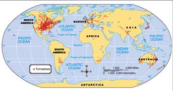
- The U.S. is the world leader in tornado production.
- This results from the regular interaction between the air mass from the
Gulf of Mexico and the air mass from the polar continent.
- The absence of topographic barriers ensures regular mixing and the
production of violent storm systems.
|
|
87
|
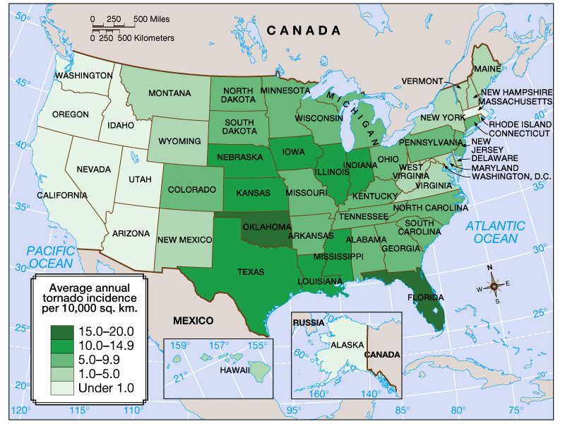
- The vast majority occur in Tornado Alley, a region from the southern
Plains to the lower Great Lakes.
- Texas has the highest tornado frequency of any state.
|
|
88
|
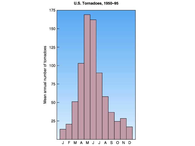
- May is the month of highest
frequency while June is a close second.
- Many states show tornado peaks during different months, however, late
spring is the time of greatest overall activity.
- It is the season when air mass contrasts are especially strong.
|
|
89
|
- Winds, not pressure change, cause the greatest amount of damage.
- Flying debris causes the greatest amount of injuries.
- Some tornadoes have multiple suction vortices which may account for
rather selective damage patterns.
- Tornadoes are classified using the Fujita scale which ranks tornadoes
based on damage.
|
|
90
|
|
|
91
|
|

 Notes
Notes