
3D View of Supercell –
Initial Development
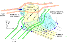
•The
inflow to the updraft initially approaches the core of the updraft from all
direction.
•Precipitation
quickly begins to fall to the north, northeast, and east, as precipitation
particles within the storm are carried downwind of the
updraft core by the middle- and upper-level winds.
•When
precipitation falls, evaporation cooling and drag lead to the formation of
downdrafts.
•The
first downdraft to form is the forward
flank downdraft (FFD).
•The
downdraft air reaches the surface and spreads rapidly outward in all
directions, creating at its leading edge the forward
flank gust front (the cold front symbols).
•As the
mid-level air approaching the storm from the southwest encounters the updraft,
cloud and precipitation particles on the rear flank
of the storm mix with dry air and evaporate.
•This air cools and descends
to the surface and forms the rear
flank downdraft (RFD)
•New cells often triggered
along the rear flank gust front.